
Page 225 - Fundamentals of Geomorphology
P. 225
208 PROCESS AND FORM
in a stream profile is a prime site. A barrier
slowly builds up, on the front side of which frothing and
bubbling encourage further deposition. The end result
is that a dam and waterfall form across a karst river.
The waterfall may move down the valley leaving a fill of
travertine in its wake.Travertine may cover large areas. In
Antalya, south-west Turkey, a travertine complex, con-
structed by the supersaturated calcareous waters of the
2
Kirkgöz spring group, occupies 600 km and has a max-
imum thickness of 270 m (Burger 1990). A sequence of
tufa dams in the Korana Valley, Croatia, impounds the
impressive Plitvice Lakes.
Karst forms on quartzite
It was once thought that quartzites were far too insolu-
ble to be susceptible to chemical weathering. Starting in
the mid-1960s with the discovery of quartzite karst
in Venezuela (White et al. 1966; see also Wirthmann
2000, 104–9), karst-like landforms have been found
on quartzose rock in several parts of the tropics. The
quartzitic sandstone plateau of the Phu Hin Rong
Kla National Park, north-central Thailand, bears fea-
tures found in limestone terrain – rock pavements,
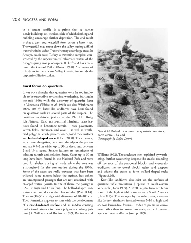
karren fields, crevasses, and caves – as well as weath- Plate 8.14 Bollard rocks formed in quartzitic sandstone,
ered polygonal crack patterns on exposed rock surfaces north-central Thailand.
and bollard-shaped rocks (Doerr 2000). The crevasses, (Photograph by Stefan Doerr)
which resemble grikes, occur near the edge of the plateau
and are 0.5–2 m wide, up to 30 m deep, and between
1 and 10 m apart. Smaller features are reminiscent of
solution runnels and solution flutes. Caves up to 30 m Williams 1992). The cracks are then exploited by weath-
long have been found in the National Park and were ering. Further weathering deepens the cracks, rounding
used for shelter during air raids while the area was off the tops of the polygonal blocks, and eventually
a stronghold for the communists during the 1970s. eradicates the polygonal blocks’ edges and deepens
Some of the caves are really crevasses that have been and widens the cracks to form bollard-shaped rocks
widened some metres below the surface, but others (Figure 8.16).
are underground passages that are not associated with Karst-like landforms also exist on the surfaces of
enlarged vertical joints. In one of them, the passage is quartzite table mountains (Tepuis) in south-eastern
0.5–1 m high and 16 m long. The bollard-shaped rock Venezuela (Doerr 1999). At 2,700 m, the KukenanTepui
features are found near the plateau edge (Plate 8.14). is one of the highest table mountains in South America
They are 30–50 cm high with diameters of 20–100 cm. (Plate 8.15). The topography includes caves, crevasse-
Their formation appears to start with the development like fissures, sinkholes, isolated towers 3–10 m high, and
of a case-hardened surface and its sudden cracking shallow karren-like features. Evidence points to corro-
under tensile stresses to form a polygonal cracking pat- sion, rather than to erosive processes, as the formative
tern (cf. Williams and Robinson 1989; Robinson and agent of these landforms (see pp. 189).