
Page 273 - Fundamentals of Geomorphology
P. 273
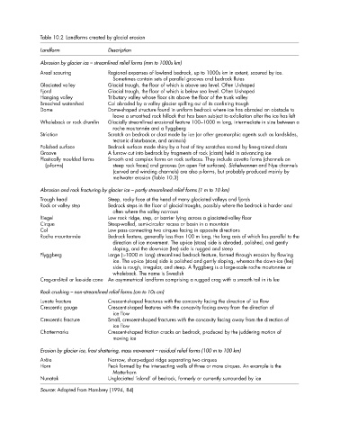
Table 10.2 Landforms created by glacial erosion
              Landform             Description

              Abrasion by glacier ice – streamlined relief forms (mm to 1000s km)
              Areal scouring       Regional expanses of lowland bedrock, up to 1000s km in extent, scoured by ice.
                                     Sometimes contain sets of parallel grooves and bedrock flutes
              Glaciated valley     Glacial trough, the floor of which is above sea level. Often U-shaped
              Fjord                Glacial trough, the floor of which is below sea level. Often U-shaped
              Hanging valley       Tributary valley whose floor sits above the floor of the trunk valley
              Breached watershed   Col abraded by a valley glacier spilling out of its confining trough
              Dome                 Dome-shaped structure found in uniform bedrock where ice has abraded an obstacle to
                                     leave a smoothed rock hillock that has been subject to exfoliation after the ice has left
              Whaleback or rock drumlin  Glacially streamlined erosional feature 100–1000 m long, intermediate in size between a
                                     roche moutonnée and a flyggberg
              Striation            Scratch on bedrock or clast made by ice (or other geomorphic agents such as landslides,
                                     tectonic disturbance, and animals)
              Polished surface     Bedrock surface made shiny by a host of tiny scratches scored by fine-grained clasts
              Groove               A furrow cut into bedrock by fragments of rock (clasts) held in advancing ice
              Plastically moulded forms  Smooth and complex forms on rock surfaces. They include cavetto forms (channels on
               (p-forms)             steep rock faces) and grooves (on open flat surfaces). Sichelwannen and Nye channels
                                     (curved and winding channels) are also p-forms, but probably produced mainly by
                                     meltwater erosion (Table 10.3)

              Abrasion and rock fracturing by glacier ice – partly streamlined relief forms (1 m to 10 km)
              Trough head          Steep, rocky face at the head of many glaciated valleys and fjords
              Rock or valley step  Bedrock steps in the floor of glacial troughs, possibly where the bedrock is harder and
                                     often where the valley narrows
              Riegel               Low rock ridge, step, or barrier lying across a glaciated-valley floor
              Cirque               Steep-walled, semi-circular recess or basin in a mountain
              Col                  Low pass connecting two cirques facing in opposite directions
              Roche mountonnée     Bedrock feature, generally less than 100 m long, the long axis of which lies parallel to the
                                     direction of ice movement. The up-ice (stoss) side is abraded, polished, and gently
                                     sloping, and the down-ice (lee) side is rugged and steep
              Flyggberg            Large (>1000 m long) streamlined bedrock feature, formed through erosion by flowing
                                     ice. The up-ice (stoss) side is polished and gently sloping, whereas the down-ice (lee)
                                     side is rough, irregular, and steep. A flyggberg is a large-scale roche moutonnée or
                                     whaleback. The name is Swedish
              Crag-and-tail or lee-side cone  An asymmetrical landform comprising a rugged crag with a smooth tail in its lee
              Rock crushing – non-streamlined relief forms (cm to 10s cm)
              Lunate fracture      Crescent-shaped fractures with the concavity facing the direction of ice flow
              Crescentic gouge     Crescent-shaped features with the concavity facing away from the direction of
                                     ice flow
              Crescentic fracture  Small, crescent-shaped fractures with the concavity facing away from the direction of
                                     ice flow
              Chattermarks         Crescent-shaped friction cracks on bedrock, produced by the juddering motion of
                                     moving ice

              Erosion by glacier ice, frost shattering, mass movement – residual relief forms (100 m to 100 km)
              Arête                Narrow, sharp-edged ridge separating two cirques
              Horn                 Peak formed by the intersecting walls of three or more cirques. An example is the
                                     Matterhorn
              Nunatak              Unglaciated ‘island’ of bedrock, formerly or currently surrounded by ice
              Source: Adapted from Hambrey (1994, 84)