
Page 300 - Fundamentals of Geomorphology
P. 300
PERIGLACIAL LANDSCAPES 283
b
a
() i () ()
Thermokarst lake
Dilation
crack
Lifting force
(hydrostatic pressure)
Permafrost Unfrozen Permafrost
saturated sands
()
ii
ermafrost
Lake drains Residual pond P Permafrost
ce
body
I Ice body
Pore water
under hydrostatic P Permafrost
ermafrost
Permafrost pressure from Permafrost
aggradation pore water expulsion aggradation
Dilation crack
() Pingo ice Sub-pingo
iii
water lens
Talik
Ta l i k
Unfrozen
pore water at < 0°C
Total uplift volume of
iv
() pingo ice and pore ice
() Collapsing pingo Pond
v
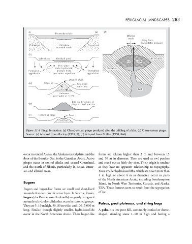
Figure 11.4 Pingo formation. (a) Closed-system pingo produced after the infilling of a lake. (b) Open-system pingo.
Sources: (a) Adapted from Mackay (1998, 8); (b) Adapted from Müller (1968, 846)
occur in central Alaska, the Alaskan coastal plain, and the forms are seldom higher than 2 m and between 15
floor of the Beaufort Sea, in the Canadian Arctic. Active and 50 m in diameter. They are used as owl perches
pingos occur in central Alaska and coastal Greenland, and stand out as fairly dry sites. Their origin is unclear
and the north of Siberia, particularly in deltas, estuar- as they bear no apparent relationship to topography.
ies, and alluvial areas. Even smaller hydrolaccoliths, which are never more than
1 m high or about4min diameter, occur in parts
of the North American Arctic, including Southampton
Bugors Island, in North West Territories, Canada, and Alaska,
Bugors and bugor-like forms are small and short-lived USA. These features seem to result from the segregation
mounds that occur in the active layer. In Siberia, Russia, of ice.
bugors(theRussianwordforknolls)aregentlyrisingoval
moundsorhydrolaccolithsthatoccurinscatteredgroups. Palsas, peat plateaux, and string bogs
They are 5–10 m high, 50–80 m wide, and 100–5,000 m
long. Similar, though slightly smaller, hydrolaccoliths A palsa is a low peat hill, commonly conical or dome-
occur in the North American Arctic. These bugor-like shaped, standing some 1–10 m high and having a