
Page 315 - Fundamentals of Geomorphology
P. 315
298 PROCESS AND FORM
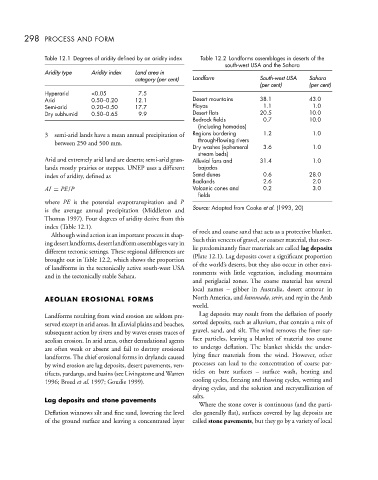
Table 12.1 Degrees of aridity defined by an aridity index Table 12.2 Landforms assemblages in deserts of the
south-west USA and the Sahara
Aridity type Aridity index Land area in
category (per cent) Landform South-west USA Sahara
(per cent) (per cent)
Hyperarid <0.05 7.5
Arid 0.50–0.20 12.1 Desert mountains 38.1 43.0
Semi-arid 0.20–0.50 17.7 Playas 1.1 1.0
Dry subhumid 0.50–0.65 9.9 Desert flats 20.5 10.0
Bedrock fields 0.7 10.0
(including hamadas)
3 semi-arid lands have a mean annual precipitation of Regions bordering 1.2 1.0
between 250 and 500 mm. through-flowing rivers
Dry washes (ephemeral 3.6 1.0
stream beds)
Arid and extremely arid land are deserts; semi-arid grass- Alluvial fans and 31.4 1.0
lands mostly prairies or steppes. UNEP uses a different bajadas
index of aridity, defined as Sand dunes 0.6 28.0
Badlands 2.6 2.0
AI = PE/P Volcanic cones and 0.2 3.0
fields
where PE is the potential evapotranspiration and P
is the average annual precipitation (Middleton and Source: Adapted from Cooke et al. (1993, 20)
Thomas 1997). Four degrees of aridity derive from this
index (Table 12.1).
Although wind action is an important process in shap- of rock and coarse sand that acts as a protective blanket.
ingdesertlandforms,desertlandformassemblagesvaryin Such thin veneers of gravel, or coarser material, that over-
different tectonic settings. These regional differences are lie predominantly finer materials are called lag deposits
brought out in Table 12.2, which shows the proportion (Plate 12.1). Lag deposits cover a significant proportion
of landforms in the tectonically active south-west USA of the world’s deserts, but they also occur in other envi-
and in the tectonically stable Sahara. ronments with little vegetation, including mountains
and periglacial zones. The coarse material has several
local names – gibber in Australia, desert armour in
AEOLIAN EROSIONAL FORMS North America, and hammada, serir, and reg in the Arab
world.
Landforms resulting from wind erosion are seldom pre- Lag deposits may result from the deflation of poorly
served except in arid areas. In alluvial plains and beaches, sorted deposits, such as alluvium, that contain a mix of
subsequent action by rivers and by waves erases traces of gravel, sand, and silt. The wind removes the finer sur-
aeolian erosion. In arid areas, other denudational agents face particles, leaving a blanket of material too coarse
are often weak or absent and fail to destroy erosional to undergo deflation. The blanket shields the under-
landforms. The chief erosional forms in drylands caused lying finer materials from the wind. However, other
by wind erosion are lag deposits, desert pavements, ven- processes can lead to the concentration of coarse par-
tifacts, yardangs, and basins (see Livingstone and Warren ticles on bare surfaces – surface wash, heating and
1996; Breed et al. 1997; Goudie 1999). cooling cycles, freezing and thawing cycles, wetting and
drying cycles, and the solution and recrystallization of
salts.
Lag deposits and stone pavements
Where the stone cover is continuous (and the parti-
Deflation winnows silt and fine sand, lowering the level cles generally flat), surfaces covered by lag deposits are
of the ground surface and leaving a concentrated layer called stone pavements, but they go by a variety of local