
Page 316 - Fundamentals of Geomorphology
P. 316
AEOLIAN LANDSCAPES 299
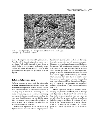
Plate 12.1 Lag deposits lying on a stone pavement, Dhakla, Western Desert, Egypt.
(Photograph by Tony Waltham Geophotos)
names – desert pavements in the USA, gibber plains in by deflation (Figure 12.2; Plate 12.2). In size, they range
Australia, gobi in Central Asia, and hammada, reg,or from a few metres wide and only centimetres deep, to
serir in the Arab world. Hammada is rocky desert, in kilometres across and tens of metres deep. The largest
which the lag consists of coarse, mechanically weath- known pan, which was discovered in eastern Australia, is
ered regolith. Serir is pebbly desert with a lag of rounded 45 km wide. Pans are prominently developed in southern
gravel and coarse sand produced by deflation of alluvial Africa, on the High Plains of the USA, in the Argentinian
deposits. pampas, Manchuria, western and southern Australia, the
west Siberian steppes, and Kazakhstan (Goudie 1999).
They sometimes have clay dunes or lunette dunes
formed on their leeside that are composed of sandy, silty,
Deflation hollows and pans
clayey, and salty material from the pan floor. The pres-
Deflation can scour out large or small depressions called ence of a lunette is a sure sign that a pan has suffered
deflation hollows or blowouts. Blowouts are the com- deflation. The evolution of pans is a matter of debate
monest landforms produced by wind erosion. They are (Box 12.1).
most common in weak, unconsolidated sediments. In Deflation appears to have played a starring role in
size, they range from less than a metre deep and a few scooping out great erosional basins, such as the large
metres across, through enclosed basins a few metres deep oasis depressions in the Libyan Desert. However, such
and hundreds of metres across (pans), to very large fea- large basins are almost certain to have had a complex
tures more than 100 m deep and over 100 km across. evolution involving processes additional to deflation,
They are no deeper than the water table, which may be including tectonic subsidence. The deepest of such
several hundred metres below the ground surface, and basins is the Qattara Depression in northern Egypt,
may attain diameters of kilometres. which is cut into Pliocene sediments. At its lowest
Pans are closed depressions that are common in many point, the Qattara Depression lies 134 m below sea
dryland areas and that seem to be at least partly formed level.