Page 351 - Fundamentals of Geomorphology
P. 351
334 PROCESS AND FORM


                                                        (cf. p. 299). They are begun by wave erosion, overwash,
                                                        a lack of aeolian deposition, or deflation of vegetation or
                                                        poorly vegetated areas. Once started, they are enlarged
                                                        by wind scour and slumping, and avalanching on the
                                                        sidewalls.


                                                        Estuaries
                                                        Estuaries are tidal inlets, often long and narrow inlets,
                                                        that stretch across a coastal alluvial plain or run inwards
                                                        along a river to the highest point reached by the tide.
                                                        They are partially enclosed but connected to the open
                                                        sea. They are transition zones between rivers and the sea
                                                        in which fresh river water mixes with salty ocean water.
                                                        Early in their evolution, their shape is determined by
                                                        coastal topography, but this changes fairly rapidly as sed-
                                                        iment erosion and deposition reach a steady state. Many
                                                        are young features formed in valleys that were carved out
                                                        during the last glacial stage and then drowned by rising
                                                        sea levels during the Holocene epoch. Figure 13.16 is a
                                                        physiographic classification due to Rhodes W. Fairbridge
                                                        (1980). Figure 13.17 shows an alternative estuary clas-
                                                        sification based upon the mixing of river water with
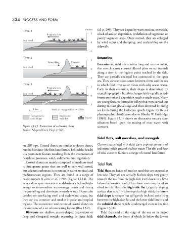
              Figure 13.13 Formation of a chenier plain.  seawater.
              Source: Adapted from Hoyt (1969)

                                                        Tidal flats, salt marshes, and mangals

              on cliff tops. Coastal dunes are similar to desert dunes,  Currents associated with tides carry copious amounts of
              buttheforedune(thefirstduneformedbehindthebeach)  sediment inside areas of shallow water. The ebb and flow
              is a prominent feature resulting from the interaction of  of tidal currents fashions a range of coastal landforms.
              nearshore processes, wind, sediments, and vegetation.
                Coastal dunes are mainly composed of medium-sized  Tidal flats
              to fine quartz grains that are well to very well sorted,
              but calcium carbonate is common in warm tropical and  Tidal flats are banks of mud or sand that are exposed at
              mediterranean regions. They are found in a range of  low tide. They are not actually flat but slope very gently
              environments (Carter et al. 1990) (Figure 13.14). The  towards the sea from the high-tide level down to a little
              largest dune systems occur in mid-latitudes, behind high-  below the low-tide level. Three basic units may be iden-
              energy to intermediate wave-energy coasts and facing  tified in tidal flats: the high-tide flat (a gently sloping
              the prevailing and dominant westerly winds. Dunes also  surface that is partly submerged at high tide); the inter-
              develop on east-facing swell and trade-wind coasts, but  tidal slope (a steeper but still gently inclined zone lying
              they are less common and smaller in polar and tropical  between the high-tide flat and the lower tidal limit); and
              regions. The occurrence and nature of coastal dunes are  the subtidal slope, which is submerged even at low tide
              the outcome of a set of interacting factors (Box 13.2).  (Figure 13.18).
                Blowouts are shallow, saucer-shaped depressions or  Tidal flats end at the edge of the sea or in major
              deep and elongated troughs occurring in dune fields  tidal channels, the floors of which lie below the lowest

