
Page 198 - Fundamentals of Physical Volcanology
P. 198
9780632054435_4_011.qxd 12/10/2007 12:33PM Page 175
VOLCANIC HAZARDS AND VOLCANO MONITORING 175
for changes in the temperature of the surface, an
obvious indicator of hot volcanic materials being
present at shallow depth, and there have been a
number of successful first recognitions of erup-
tion in the process of breaking out, especially in
unpopulated areas. Satellites can also monitor the
appearance of the surface: changes in the color,
texture, or reflectivity might indicate, for example,
the poisoning of vegetation by enhanced release of
volcanic gases. The main limitation of these tech-
niques at the moment is the long interval between
obtaining images of the same point on the surface
with the same detector, so that a reliable compari-
son can be made to detect changes. However, once
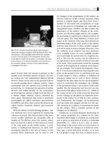
Fig. 11.13 A Fourier transform infrared spectrometer the outbreak of an eruption has been detected,
taking data during an eruption of Mount Etna in 2001. The
every available sensor on every available satellite
instrument is collecting light emitted from the eruption
can in principle be turned onto the eruption site,
column. Volcanic gases in the atmosphere absorb some
and in this way the activity can be followed in
of the light at certain characteristic wavelengths, allowing
their presence to be detected and their concentrations to enough detail to allow reliable short-term forecasts
be measured. (Image courtesy of Clive Oppenheimer, to be made. This is particularly useful for warning
Cambridge University.) aircraft of developments in eruption cloud disper-
sal, for example. One modern development where
the 2–3 week interval between observing the same
gases, if more than one species is present, as the point on the ground is less of a problem is the use
sample cools. Real-time analysis of gases can now of radar images to detect inflation or deflation of
be carried out with miniaturized infrared LICOR volcanoes. Radar can be used to detect distance
devices. These can be used on the ground or flown changes by the time taken for the electromagnetic
in aircraft passing above volcanic centers. Other waves to travel from the transmitter on a satellite
instruments that can operate from aircraft or the to the ground and back to the receiver on the same
ground (Fig. 11.13) measure the amounts of carbon satellite. But the transmitter and receiver can also
dioxide and sulfur dioxide in the atmosphere keep track of the phase of the waves, i.e., where in
by detecting the amount of light from the Sun (or the course of one cycle of the waves the detection
a distant bright artificial source) absorbed by occurs. Changes in the phase can represent move-
these gases. Instruments that work at ultraviolet ments of the surface by as little as a few centime-
wavelengths are called correlation spectrometers ters. Furthermore, the changes can be monitored
(COSPECs) and those that work in the infrared are over the entire area imaged, not just at a few spe-
called Fourier transform infrared spectrometers cific locations as is typical of measurements made
(FTIRs). on the surface. Thus a synoptic picture of the
With the advent of Earth-orbiting satellites, vari- changes can be obtained.
ous methods have been explored for monitoring Continuous, or at least frequent, monitoring of
volcanoes remotely. The characteristics of the more the various properties of a volcano in the ways
recent satellite platforms are near-polar orbit at described above helps to establish its normal state
heights of 700–800 km above the surface, which and so gives an indication of when it is behaving
gives an interval of about 16 days between revisits abnormally, i.e., when it is in a state of unrest.
of the same point on the Earth’s surface. A wide Depending on the extent of the recorded history of
variety of multispectral detectors are used, with a given volcano, the changes in its behavior some-
resolutions typically a few tens of meters on the times give a good indication of when, or at least
ground. These instruments can be used to look if, it is going to erupt. But there is almost never a