
Page 98 - Geotechnical Engineering Soil and Foundation Principles and Practice
P. 98
Soils That Are Sediments
Soils That Are Sediments 93
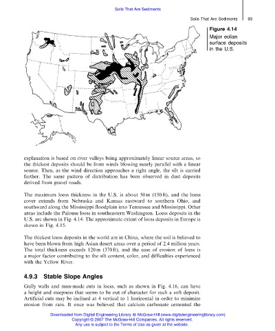
Figure 4.14
Major eolian
surface deposits
in the U.S.
explanation is based on river valleys being approximately linear source areas, so
the thickest deposits should be from winds blowing nearly parallel with a linear
source. Then, as the wind direction approaches a right angle, the silt is carried
farther. The same pattern of distribution has been observed in dust deposits
derived from gravel roads.
The maximum loess thickness in the U.S. is about 50 m (150 ft), and the loess
cover extends from Nebraska and Kansas eastward to southern Ohio, and
southward along the Mississippi floodplain into Tennessee and Mississippi. Other
areas include the Palouse loess in southeastern Washington. Loess deposits in the
U.S. are shown in Fig. 4.14. The approximate extent of loess deposits in Europe is
shown in Fig. 4.15.
The thickest loess deposits in the world are in China, where the soil is believed to
have been blown from high Asian desert areas over a period of 2.4 million years.
The total thickness exceeds 120 m (370 ft), and the ease of erosion of loess is
a major factor contributing to the silt content, color, and difficulties experienced
with the Yellow River.
4.9.3 Stable Slope Angles
Gully walls and man-made cuts in loess, such as shown in Fig. 4.16, can have
a height and steepness that seems to be out of character for such a soft deposit.
Artificial cuts may be inclined at 4 vertical to 1 horizontal in order to minimize
erosion from rain. It once was believed that calcium carbonate cemented the
Downloaded from Digital Engineering Library @ McGraw-Hill (www.digitalengineeringlibrary.com)
Copyright © 2007 The McGraw-Hill Companies. All rights reserved.
Any use is subject to the Terms of Use as given at the website.