
Page 136 - Global Tectonics
P. 136
122 CHAPTER 6
6.1 OCEAN RIDGE gross topography of the East Pacific Rise, which is rela-
tively smooth, even in the crestal region, contrasts with
TOPOGRAPHY the rugged topography of the Mid-Atlantic Ridge,
which typically has a median rift valley at its crest. This
can now be seen to correlate with the systematically
different spreading rates on the two ridges (Fig. 5.5),
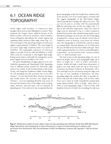
Ocean ridges mark accretive, or constructive plate that is, fast and slow respectively. These two types of
margins where new oceanic lithosphere is created. They ridge crest are illustrated in Fig. 6.1, which is based on
represent the longest, linear uplifted features of the detailed bathymetric data obtained using deeply towed
Earth’s surface, and can be traced by a belt of shallow instrument packages. In each case, the axis of spreading
focus earthquakes that follows the crestal regions and is marked by a narrow zone of volcanic activity that is
transform faults between offset ridge crests (Fig. 5.2). flanked by zones of fissuring. Away from this volcanic
The total length of the spreading margins on mid-ocean zone, the topography is controlled by vertical tectonics
ridges is approximately 55,000 km. The total length of on normal faults. Beyond distances of 10–25 km from
the active ridge–ridge transform faults is in excess of the axis, the lithosphere becomes stable and rigid. These
30,000 km. The topographic expression of mid-ocean stable regions bound the area where oceanic lithosphere
ridges is typically between 1000 and 4000 km in width. is generated – an area known as the “crestal accretion
Their crests are commonly 2–3 km higher than neigh- zone” or “plate boundary zone”.
boring ocean basins, and locally the topography can be The fault scarps on fast-spreading ridges are tens of
quite rugged and runs parallel to the crests. meters in height, and an axial topographic high, up to
The gross morphology of ridges appears to be con- 400 m in height and 1–2 km in width, commonly is
trolled by separation rate (Macdonald, 1982). Spreading present. Within this high a small linear depression, or
rates at different points around the mid-ocean ridge graben, less than 100 m wide and up to 10 m deep is
system vary widely. In the Eurasian basin of the Arctic sometimes developed (Carbotte & Macdonald, 1994).
Ocean, and along the Southwest Indian Ocean Ridge, The axial high may be continuous along the ridge crest
the full spreading rate (the accretion rate) is less than for tens or even hundreds of kilometers. On slow-
−1
20 mm a . On the East Pacifi c Rise, between the Nazca spreading ridges the median rift valley is typically 30–
and Pacific plates, the accretion rate ranges up to 50 km wide and 500–2500 m deep, with an inner valley
−1
150 mm a . It is not surprising therefore that many of floor, up to 12 km in width, bounded by normal fault
the essential characteristics of the ridges, such as topog- scarps approximately 100 m in height. Again there is
raphy, structure, and rock types, vary as a function of often an axial topographic high, 1–5 km in width, with
spreading rate. Very early on it was recognized that the hundred of meters of relief, but extending for only tens
(a) P F VV F P
Fast
(EPR 3° S)
P
P
(b) F VV F
Slow
VE ~ 4 x
Axis (MAR 37° N)
20 10 0 10 20 30
km
Fig. 6.1 Bathymetric profiles of ocean ridges at fast and slow spreading rates. EPR, East Pacific Rise; MAR, Mid-Atlantic
Ridge. Neovolcanic zone bracketed by Vs, zone of fissuring by Fs, extent of active faulting by Ps (redrawn with
permission from MacDonald, 1982, Annual Review of Earth and Planetary Sciences 10. Copyright © 1982 by Annual
Reviews).