
Page 219 - Global Tectonics
P. 219
CONTINENTAL RIFTS AND RIFTED MARGINS 205
(a) 148°E 154°E 160°E
5° S 5° S
New Britain
7° S Solomon Sea Solomon Islands 7° S
9° S 9° S
PNG
11° S 11° S
Woodlark Basin
Coral Sea
13° S 13° S
148°E 154°E 160°E
(b)
o
5 S
NEW
NEW BRITAIN Pacific Plate GUINEA
NEW BRITAIN TRENCH Solomon AUSTRALIA
D
Sea
B SOLOMON ISLANDS
TROBRIAND TROUGH
PAPUAN DI WOODLARK RISE WOODLARK
PENINSULA MS
10 S BASIN
o
Subduction Zone POCKLINGTON RISE POCKLINGTON TROUGH SAN CRISTOBAL TRENCH
2000 m Isobath
Neovolcanic Zone A
Brunhes Chron Australian Plate
Continent/Ocean Boundary
Strike-Slip Fault & Fracture Zone Coral Sea
C 150 E 155 E 160 E
o
o
o
A B
(c)
12°S 11°S 10°S 9°S 8°S
VE = 3 Pocklington Rise Woodlark Rise
5 km MS
10.4°S 10.0°S 9.6°S 9.2°S
VE = 1 DG
Moresby D D
Seamount detachment fault
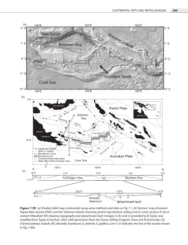
Figure 7.39 (a) Shaded relief map constructed using same methods and data as Fig. 7.1. (b) Tectonic map of eastern
Papua New Guinea (PNG) and the Solomon Islands showing present-day tectonic setting and (c) cross-section (A–B) of
western Woodlark Rift showing topography and detachment fault (images in (b) and (c) provided by B. Taylor and
modified from Taylor & Huchon, 2002, with permission from the Ocean drilling Program, Texas A & M University). DI,
D’Entrecasteaux Islands; MS, Moresby Seamount; D, dolerite; G, gabbro. Line C–D indicates the line of the section shown
in Fig. 7.40a.