
Page 221 - Global Tectonics
P. 221
Arc line
(a)
Papuan Peninsula
5
0
-5
-15 DI Trobriand Trough
Coral Sea
OSM GB
KM -25
PUB
-35 Mantle lithosphere PUB
Papuan Plateau continental crust
-45 Hydrated crust
Solomon Sea lithosphere
and mantle
148°E
Asthenosphere
149°E
150°E
151°E
(b) 152°E 13°S 12°S 11°S 10°S 9°S 8°S 7°S
4 3
100 km
2 1
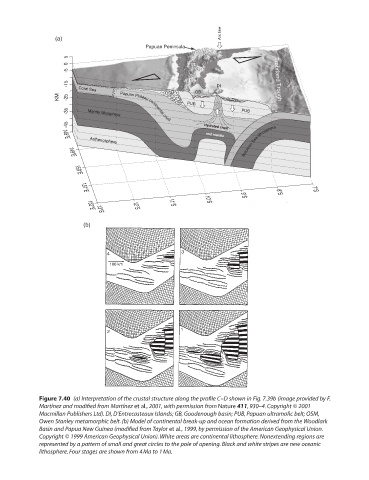
Figure 7.40 (a) Interpretation of the crustal structure along the profile C–D shown in Fig. 7.39b (image provided by F.
Martínez and modified from Martínez et al., 2001, with permission from Nature 411, 930–4. Copyright © 2001
Macmillan Publishers Ltd). DI, D’Entrecasteaux Islands; GB, Goodenough basin; PUB, Papuan ultramafic belt; OSM,
Owen Stanley metamorphic belt. (b) Model of continental break-up and ocean formation derived from the Woodlark
Basin and Papua New Guinea (modified from Taylor et al., 1999, by permission of the American Geophysical Union.
Copyright © 1999 American Geophysical Union). White areas are continental lithosphere. Nonextending regions are
represented by a pattern of small and great circles to the pole of opening. Black and white stripes are new oceanic
lithosphere. Four stages are shown from 4 Ma to 1 Ma.