
Page 226 - Global Tectonics
P. 226
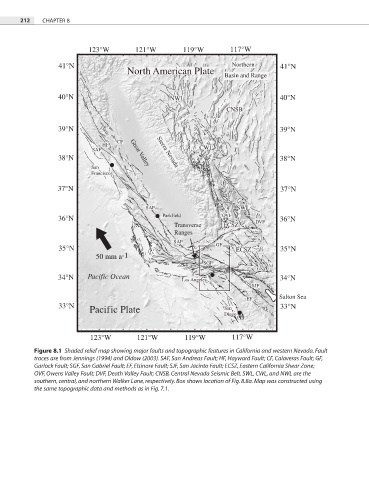
212   CHAPTER 8


                           123°W        121°W         119°W         117°W

                  41°N                                              Northern      41°N
                                      North American Plate
                                                                  Basin and Range


                  40°N                            NWL                             40°N
                                                                   CNSB


                  39°N                                                            39°N
                                   CF
                               HF
                            SAF        Great Valley  Sierra Nevada  CWL
                  38°N                                                            38°N
                            San
                            Francisco

                  37°N                                                            37°N

                                           SAF                        SWL
                                                Parkfield        OVF
                  36°N                                                     DVF    36°N
                                                    Transverse    ECSZ
                                                    Ranges
                                                   SAF          GF
                  35°N                                                ECSZ        35°N
                             50 mm a -1
                                                            SGF

                  34°N    Pacific Ocean               Los Angeles                 34°N
                                                                          SJF
                                                                                  Salton Sea
                                                                         EF
                  33°N                                            San             33°N
                           Pacific Plate
                                                                  Diego


                           123°W         121°W         119°W        117°W
           Figure 8.1  Shaded relief map showing major faults and topographic features in California and western Nevada. Fault
           traces are from Jennings (1994) and Oldow (2003). SAF, San Andreas Fault; HF, Hayward Fault; CF, Calaveras Fault; GF,
           Garlock Fault; SGF, San Gabriel Fault; EF, Elsinore Fault; SJF, San Jacinto Fault; ECSZ, Eastern California Shear Zone;
           OVF, Owens Valley Fault; DVF, Death Valley Fault; CNSB, Central Nevada Seismic Belt. SWL, CWL, and NWL are the
           southern, central, and northern Walker Lane, respectively. Box shows location of Fig. 8.8a. Map was constructed using
           the same topographic data and methods as in Fig. 7.1.