Page 227 - Global Tectonics
P. 227

CONTINENTAL TRANSFORMS AND STRIKE-SLIP FAULTS  213


                   165°E       167°E       169°E        171°E       173°E       175°E
              (a)
                                                                       Median
                                                                       Batholith
             41°S                                                                             41°S
                            Australian Plate                           WF

             42°S                                                      AF CF                  42°S
                                                                                    Hikurangi
                                                                                    Trench
                                                                     HF
             43°S                                                                 45 mm a -1  43°S

                                            SOUTHERN                  Canterbury
                       Tasman Sea            Alpine Fault  ALPS      Christchurch
             44°S                                           Plain                             44°S


                             Fig. 8.9a       Haast Schist
             45°S                     HFF                     SIGHT profile                   45°S
                                                                         Pacific Ocean
                          Fiordland
                                        35 mm a -1
             46°S                                      Dunedin                                46°S

                              FBF  Median                       Pacific Plate
                                  Batholith
                        Puysegur
             47°S       Trench           Stewart Island                                       47°S

                   165°E       167°E       169°E        171°E       173°E      175°E


              (b)        West coast      Southern Alps        Canterbury Plain  East coast
                 0
                                          Exhumation     Graywacke
                10  6.0 km s  1  5.9 km s  1  Alpine fault  Haast schist  6.0 km s  1  6.2 km s  1  6.0 km s  1
              Depth (km)  20  8.1 km s  1 6.5 km s  1  Crustal root  Décollement  ?   1  6.3 km s  1  Lower crust  7.1 km s  1   1
                                                1
                                           5.7 km s
                                                      1
                                                 5.8 km s
                30
                                                                                      8.1 km s
                                                         6.9 km s
                40                     7.8 km s  1   8.0 km s  1  8.5 km s  1  8.2 km s  1
                    Australian plate         Lower crust                Pacific plate
                  180   200    220    240    260   280    300    320    340   360    380    400
                                                   Distance (km)
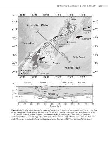
            Figure 8.2  (a) Shaded relief map showing major faults and tectonic features of the Australian-Pacific plate boundary

            on the South Island of New Zealand. Map was constructed using the same topographic data and methods as in Fig.
            7.1. WF, Wairau Fault; AF, Awatere Fault; CF, Clarence Fault; HF, Hope Fault; HFF, Hollyford Fault; FBF, Fiordland

            Boundary Fault. (b) Seismic velocity profile constructed without vertical exaggeration (modified from Van Avendonk

            et al., 2004, by permission of the American Geophysical Union. Copyright © 2002 American Geophysical Union).
   222   223   224   225   226   227   228   229   230   231   232