
Page 229 - Global Tectonics
P. 229
CONTINENTAL TRANSFORMS AND STRIKE-SLIP FAULTS 215
Kaipo river Lake McKerrow Cascade river
(a) 0 10 20
Big Bay
Alpine Fault
km
N
(c)
(c)
Pyke river
Pyke river Jacksons Bay
(b)
(b) Alpine Fault
(b) (c)
Big Bay
Cascade coastal plain
river
100 Alpine Fault
100
Martyr 200
river 300
400
200 500
100
200 600
200 280
Pyke
river
Alpine Fault 200 valley
300
400
600 400
500
700 500
Contour extrapolation
with control points N 0 500 1000 2000
Moraine crest meters
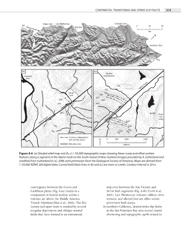
Figure 8.4 (a) Shaded relief map and (b, c) 1 : 50,000 topographic maps showing linear scarp and offset surface
features along a segment of the Alpine Fault on the South Island of New Zealand (images provided by R. Sutherland and
modified from Sutherland et al., 2006, with permission from the Geological Society of America). Maps are derived from
1 : 50,000 NZMS 260 digital data. Curved bold black lines in (b) and (c) are rivers or creeks. Contour interval is 20 m.
convergence between the Cocos and step-over between the San Vicente and
Caribbean plates (Fig. 8.6a) results in a Berlin fault segments (Fig. 8.6b) (Corti et al.,
component of dextral motion within a 2005). Late Pleistocene volcanic edifi ces, river
volcanic arc above the Middle America terraces, and alluvial fans are offset across
Trench (Martínez-Díaz et al., 2004). The Río prominent fault scarps.
Lempa pull-apart basin is marked by several In northern California, dextral strike-slip faults
irregular depressions and oblique normal in the San Francisco Bay area record crustal
faults that have formed in an extensional shortening and topographic uplift related to