Page 233 - Global Tectonics
P. 233

(a)
                GARLOCK  FAULT        Mojave
                                           Dry lakes  N

                  SAN
                                      Desert

                              ANDREAS
                                                         Line 1
                            Central       FAULT
                   SAN
                    Santa   6.7b
                   Clarita  Valley  San                ZONE
                                   Transverse
                Santa Susana
                  Mts        GABRIEL
                    SSF
                                           Gabriel
                          SF         FAULT
                        MHF                        Ranges
                    6.7a  NHF   SMFZ   5.8                Mts
                   San  Fernando
                              VF
                            Valley      RF
                 Santa   Monica  Mts  San    Gabriel  SMFZ
                               HF         Valley
                  MCF    SMoF  Los
                      Santa    Angeles  5.9  Puente
                      Monica  NEWPORT –  INGLEWOOD  Hills  WHITTIER FAULT  34˚N
                                 Los Angeles   Basin

                                                    Peninsular

                  California
                   Area   Pacific  Ocean  FAULT 6.3    Ranges
                  of map                 118˚W
                                                     km
                       0  10  20  30  40  50  60  70
                                                              San     San
                          Puente              Sierra  San             Andreas
               (b)         Hills   Whittier  Madre   Gabriel  Gabriel         Mojave
                                                              Mts
                           Fault    Fault     Fault   Fault           Fault   Desert
                   0         2                        5                         5               0
                               3  4                      6                       5.95            5.0 5
                                                                             6.05  6.1  6.3     6.15
                                                         5.9
                 Depth (km)  10  6.1  ?  5.9     ?      5.8  5.9  5.8 6.3     wide-angle        10
                               5
                                           6.8
                                                                               Mojave
                                     San Gabriel
                  20
                       Line 1  6.7  bright reflective zone   6.7              reflections  V.E. 1:1  20
                                                                      Reflector discontinuity    6.3
                                                              6.5
                                                                            100
                      0    10   20    30   40    50    60   70    80   90   6.3   110  120   130
                  30         7.8                7.8     M                                     7.8 30
                                                     Distance (km)
                                                                 M

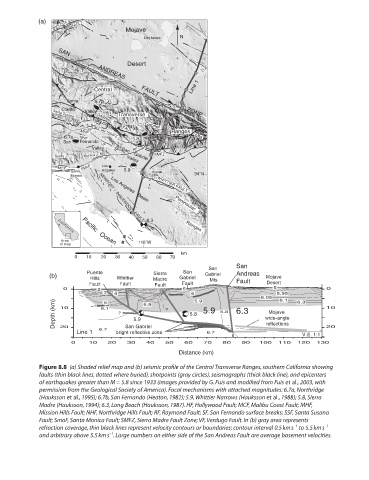
            Figure 8.8  (a) Shaded relief map and (b) seismic profile of the Central Transverse Ranges, southern California showing
            faults (thin black lines, dotted where buried), shotpoints (gray circles), seismographs (thick black line), and epicenters
            of earthquakes greater than M = 5.8 since 1933 (images provided by G. Fuis and modified from Fuis et al., 2003, with

            permission from the Geological Society of America). Focal mechanisms with attached magnitudes: 6.7a, Northridge
            (Hauksson et al., 1995); 6.7b, San Fernando (Heaton, 1982); 5.9, Whittier Narrows (Hauksson et al., 1988); 5.8, Sierra
            Madre (Hauksson, 1994); 6.3, Long Beach (Hauksson, 1987). HF, Hollywood Fault; MCF, Malibu Coast Fault; MHF,
            Mission Hills Fault; NHF, Northridge Hills Fault; RF, Raymond Fault; SF, San Fernando surface breaks; SSF, Santa Susana
            Fault; SmoF, Santa Monica Fault; SMFZ, Sierra Madre Fault Zone; VF, Verdugo Fault. In (b) gray area represents
                                                                                      −1
                                                                                               −1
            refraction coverage, thin black lines represent velocity contours or boundaries; contour interval 0.5 km s  to 5.5 km s
                                 −1
            and arbitrary above 5.5 km s . Large numbers on either side of the San Andreas Fault are average basement velocities.
   228   229   230   231   232   233   234   235   236   237   238