
Page 235 - Global Tectonics
P. 235
CONTINENTAL TRANSFORMS AND STRIKE-SLIP FAULTS 221
(a) 166 E 45 30 S 166 15 E 45 15 S 166 30 E
Fiordland Basin
166 E
PAC-AUS
Alpine 35 mm a -1 Composite Dagg-Breaksea Basin
Fault
Five Fingers 166 45 E
Basin Dagg Ridge
Five Fingers
Ridge
Breaksea Basin Dagg Basin
? ? Fig. 8.9c ¸ Fig. 8.9b
45 45 S Anchor Fault Zone
N 45 15 S
?
100 m
Chalky Fault Zone
166 15 E
Five Fingers Fault
FIORDLAND
RESOLUTION 167 E
100 m ISLAND
166 30 E 45 45 S 166 45 E 45 30 S 167 E
0 2.5 5 10 Active strike-slip fault Active thrust fault Subsiding basin (transtensional)
Kilometers Inactive strike-slip fault Inactive thrust fault Uplifted ridge (transpressional)
(b) (c)
NW SE NW Alpine Fault zone SE
Resolution Segment
3.0 Alpine Fault zone
Resolution Segment Dagg Ridge Southern end of
Dagg Basin
Dagg Basin Canyon depocenter
4.0 erosion
4.0 Back of accretionary DB3 DB1 DB2 DB3
wedge DB3
DB3 DB3
Fiordland Inactive DB4 DB3 ?
TWT (s) 5.0 faults TWT (s) DB4
Basin
A
B 5.0 Strike-slip
push up
6.0
Active reverse fault
(with strike-slip
component?) 2 km
2 km
VE 2.2 at
2 km s 1 6.0 VE 2.2 at
2 km s 1
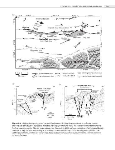
Figure 8.9 (a) Map of the south-central coast of Fiordland and (b,c) line drawings of seismic reflection profiles
showing active faults, strike-slip basins, and other physiographic features along the southern segment of the Alpine
Fault (images provided by P. Barnes and modified from Barnes et al., 2005, with permission from the Geological Society
of America). Map location shown in Fig. 8.2a. Profile (b) shows the subsiding part of the Dagg Basin, profile (c) the
uplifting part. Profile locations are shown in (a). Solid faults are active, dashed faults are inactive. Labeled reflections
are unconformities.