Page 231 - Global Tectonics
P. 231

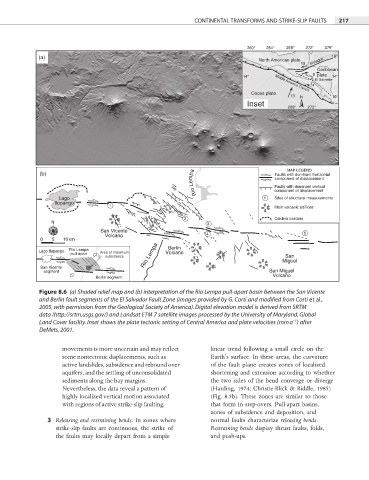
CONTINENTAL TRANSFORMS AND STRIKE-SLIP FAULTS  217


                                                                         260°  264°  268°  272°  276°
            (a)                                                             North American plate  18°
                                                                                        19   Motagua
                                                                                             Caribbean

                                                                        14°                 8 plate  14°
                                                                                            El Salvador
                                                                                           14
                                                                                 Middle America Trench
                                                                          Cocos plate
                                                                                     73  N       10°
                                                                         Inset
                                                                                     268°  272°


                                                          Río Lempa              Faults with dominant vertical
                                                                                    MAP LEGEND
             (b)                                                                 Faults with dominant horizontal
                                                                                 component of displacement

                  Lago                                                        1  component of displacement
                                                                                 Sites of structural measurements
                 Ilopango
                                 1                                               Main volcanic edifices
                                                      2                          Caldera borders
                N                                            3
                W  E          San Vicente                                                5
                               Volcano                       4
                S
             0  5  10 km
            Lago Ilopango  Río Lempa  Area of maximum  Berlin
                     pull-apart                  Volcano
                                                                                    San
                                subsidence  Río Lempa                              Miguel
             San Vicente
              segment                                                          San Miguel
                             Berlin segment                                     Volcano
            Figure 8.6  (a) Shaded relief map and (b) interpretation of the Río Lempa pull-apart basin between the San Vicente
            and Berlin fault segments of the El Salvador Fault Zone (images provided by G. Corti and modified from Corti et al.,

            2005, with permission from the Geological Society of America). Digital elevation model is derived from SRTM
            data (http://srtm.usgs.gov/) and Landsat ETM 7 satellite images processed by the University of Maryland, Global
                                                                                      −1
            Land Cover facility. Inset shows the plate tectonic setting of Central America and plate velocities (mm a ) after
            DeMets, 2001.

                   movements is more uncertain and may refl ect   linear trend following a small circle on the
                   some nontectonic displacements, such as    Earth’s surface. In these areas, the curvature
                   active landslides, subsidence and rebound over   of the fault plane creates zones of localized
                   aquifers, and the settling of unconsolidated   shortening and extension according to whether
                   sediments along the bay margins.           the two sides of the bend converge or diverge
                   Nevertheless, the data reveal a pattern of   (Harding, 1974; Christie-Blick & Biddle, 1985)
                   highly localized vertical motion associated   (Fig. 8.5b). These zones are similar to those
                   with regions of active strike-slip faulting.  that form in step-overs. Pull-apart basins,
                                                              zones of subsidence and deposition, and
               3  Releasing and restraining bends. In zones where   normal faults characterize releasing bends.
                 strike-slip faults are continuous, the strike of   Restraining bends display thrust faults, folds,
                 the faults may locally depart from a simple   and push-ups.
   226   227   228   229   230   231   232   233   234   235   236