
Page 228 - Global Tectonics
P. 228
214 CHAPTER 8
35°30
(b)
1967 Dead Sea
Shoreline
ISRAEL
(a) ISRAEL DEAD SEA
LEGEND
Strike-slip fault
Fold Bitlis - Zagros suture JordanJordan
0 100 Km (Western border)(Western border) Sedom Fault Sedom Fault
Arabian Plate FaultFault
0 10 Km
Jordan
River
Mediterranean Transform 31°00 (Khunaizira) 31°00
Israel
Amazyahu
Amazyahu
Sea
(Khunaizira)
Dead Sea Jordan Iddan Fault
Fault
Iddan
FaultFault
A
Dead Sea Lisan
Wadi Arava (Eastern Border) Fault
Wadi Arava (Eastern Border) Fault
A' JORDAN
JORDAN
N
Area of study
Nubian Plate
zone
Red Sea spreading
35°30
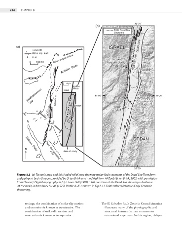
Figure 8.3 (a) Tectonic map and (b) shaded relief map showing major fault segments of the Dead Sea Transform
and pull-part basin (images provided by U. ten Brink and modified from Al-Zoubi & ten Brink, 2002, with permission
from Elsevier). Digital topography in (b) is from Hall (1993), 1967 coastline of the Dead Sea, showing subsidence
of the basin, is from Neev & Hall (1979). Profile A–A′ is shown in Fig. 8.11. Folds reflect Mesozoic–Early Cenozoic
shortening.
settings, the combination of strike-slip motion The El Salvador Fault Zone in Central America
and extension is known as transtension. The illustrates many of the physiographic and
combination of strike-slip motion and structural features that are common to
contraction is known as transpression. extensional step-overs. In this region, oblique