
Page 306 - Global Tectonics
P. 306
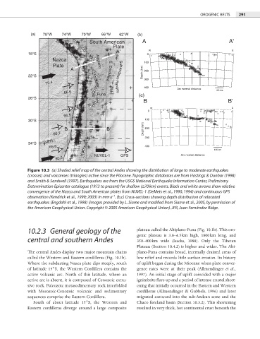
OROGENIC BELTS  291


              (a)  78°W    74°W    70°W    66°W   62°W    (b)
                                      South American        A                                  A'
                                                Plate
                                                 A'           W                                  E
             18°S                                             0
                       Nazca             Altiplano          100

                       Plate
                              A               E. Cordillera  200
             22°S                                 Subandean Ranges  Depth (km)  300
                    79.4
                                                            400           Arc normal distance
                           66.6          Puna             (c)                             100 km
             26°S
                                                            B                                  B'
                                                               W                                 E
                                                              0
                           66.5
             30°S                                            100
                            B                B'             Depth (km)  200
                       66.7
                                                             300
                    JFR
             34°S
                     66.6                                    400
                                                                                         100 km
                                        NUVEL-1    GPS                      Arc normal distance
                        80.3
            Figure 10.3  (a) Shaded relief map of the central Andes showing the distribution of large to moderate earthquakes
            (crosses) and volcanoes (triangles) active since the Pliocene. Topographic databases are from Hastings & Dunbar (1998)
            and Smith & Sandwell (1997). Earthquakes are from the USGS National Earthquake Information Center, Preliminary
            Determination Epicenter catalogue (1973 to present) for shallow (≤70 km) events. Black and white arrows show relative
            convergence of the Nazca and South American plates from NUVEL-1 (DeMets et al., 1990, 1994) and continuous GPS
                                               −1
            observation (Kendrick et al., 1999; 2003) in mm a . (b,c) Cross-sections showing depth distribution of relocated
            earthquakes (Engdahl et al., 1998) (images provided by L. Siame and modified from Siame et al., 2005, by permission of

            the American Geophysical Union. Copyright © 2005 American Geophysical Union). JFR, Juan Fernández Ridge.


            10.2.3  General geology of the               plateau called the Altiplano-Puna (Fig. 10.1b). This oro-
                                                         genic plateau is 3.8–4.5 km high, 1800 km long, and
            central and southern Andes                   350–400 km wide (Isacks, 1988). Only the Tibetan
                                                         Plateau (Section 10.4.2) is higher and wider. The Alti-
            The central Andes display two major mountain chains   plano-Puna contains broad, internally drained areas of
            called the Western and Eastern cordilleras (Fig. 10.1b).   low relief and records little surface erosion. Its history
            Where the subducting Nazca plate dips steeply, south   of uplift began during the Miocene when plate conver-
            of latitude 15°S, the Western Cordillera contains the   gence rates were at their peak (Allmendinger  et al.,
            active volcanic arc. North of this latitude, where an   1997). An initial stage of uplift coincided with a major
            active arc is absent, it is composed of Cenozoic extru-  ignimbrite flare-up and a period of intense crustal short-

            sive rock. Paleozoic metasedimentary rock interfolded   ening that initially occurred in the Eastern and Western
            with Mesozoic-Cenozoic volcanic and sedimentary   cordilleras (Allmendinger & Gubbels, 1996) and later
            sequences comprise the Eastern Cordillera.   migrated eastward into the sub-Andean zone and the
               South of about latitude 15°S, the Western and   Chaco foreland basin (Section 10.3.2). This shortening
            Eastern cordilleras diverge around a large composite   resulted in very thick, hot continental crust beneath the