
Page 311 - Global Tectonics
P. 311
OROGENIC BELTS 295
0 10 20 30 40 50 60 70 80 90 100 0 10 20 30 40 50 60 70 80 90 100 110 120 130 140
E 360 E 360
8.1 8.1 200 500
340 Uyuni-Kenayani Fault 340
67 W 5.9–6.1 5.9–6.1 320 300 67 W Shear fabric? Continental mantle 320 300
Altiplano Receiver Function Moho 280 260 Phanerozoic sediments and volcanics 280 260
3.6–5.0 240 Thickened, partially molten backarc crust 700–1000 Transitional Moho 240
68 W 220 200 68 W Top of melt and fluid layer 220 200
West. Cordillera 6.4 6.4 ALVZ ALVZ 180 arc 800 C Transparent 180
LVZ LVZ 160 140 Volcanic Front 160 140
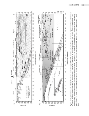
Precordillera 69 W 6.7–7.1 6.7–7.1 8.1 8.1 120 West Fissure 69 W QBBS Fluid or melt and andesite intrusions Fluid trap above slab 120 (a) Seismic results and (b) interpretation of depth-migrated ANCORP reflection data, including onshore wide-angle and receiver function results
Long. valley 3.6–6.0 6.5–6.9 6.5–6.9 7.6–7.8 7.6–7.8 100 80 60 Distance from coast (km) 100 80 60 Distance from coast (km) of Yuan et al. (2000) merged with offshore results of CINCA experiment (Patzwahl et al., 1999) (image provided by O. Oncken and modified from ANCORP Working Group, 2003, by permission of the American Geophysical Union. Copyright © 2003 American Geophysical Union). Location
Receiver Function Moho
Coastal Cordillera 6.4 6.4 Receiver Function Moho 40 Atacama Fault Hydrated mantle? 40
ANCORP 70 W 8.1 8.1 20 70 W Intruded forarc crust underplating? 800 C 20
Coast 0 Jurassic 500 C 0
6.4 6.4 20 Blueschists 20
CINCA 6.0 6.0 6.5 6.5 7.0 7.0 6.5 6.5 7.2 7.2 8.1 8.1 40 40
60 60
3.5 3.5
71 W 6.1 6.1 5.1 5.1 7.2 7.2 8.1 8.1 80 71 W Oceanic crust Oceanic mantle lithosphere alternative interpretation 80
Trench 3.5 3.5 5.0 5.0 7.2 7.2 8.1 8.1 2D-velocity Model from 2D-velocity Model from CINCA95 WA Seismic CINCA95 WA Seismic Line 201/202 Line 201/202 100 100
1.5 4.5 1.5 120 200 C 120
8.1
7.2
4.5
8.1
7.2
140 140
W W
0 10 20 30 40 50 60 70 80 90 0 10 20 30 40 50 60 70 80 90 Figure 10.6
(a) Depth (km) 100 (b) Depth (km) 100 110 120 130 140 Spot.