
Page 348 - Global Tectonics
P. 348
(a)
116°E 118°E 120°E 122°E 124°E 126°E 128°E
6°S
BANDA SEA
BANDA SEA
BANDA SEA
2000 Damar
2000
2000
Damar
Damar
4000
4000
THRUST
THRUST
4000 A A THRUST 4000
4000
4000
Romang
Romang
Romang
Wetar
Wetar
Thrust
Thrust
Suture
Suture
Wetar
Wetar
Flores
Flores
Flores Thrust Wetar Wetar Suture
Babar
Babar
8°S Moa Babar
Moa
Moa
Alor
Alor
Alor
Sermata
Sermata
Flores
Flores
Lombok Flores Sermata
Lombok
Lombok
Wetar
Wetar
Sumbawa
Sumbawa Wetar 2000
Sumbawa
2000
2000
2000
2000
2000 H 2000
2000
2000
Timor
Timor
Timor Trough
Timor Trough
SAVU
SAVU
SAVU SEA Timor
200
200
SEA Timor Trough 200
SEA
Sumba
Sumba
Sumba
10°S 2000
2000
2000
Savu Thrust
Savu Thrust
Savu Thrust
Savu
Savu
4000
AUSTRALIAN CONTINENTAL SHELF
4000
4000 Savu
AUSTRALIAN CONTINENTAL SHELF
Roti
Roti
Roti
4000
4000
4000 Roti-Savu Ridge
DSDP
DSDP
6000
6000
6000 DSDP Depth km
Site 262
Site
262
Site 262
Java Trench 75–100
Java Trench
Java Trench
12°S AUSTRALIAN CONTINENTAL SHELF 101–200
201–300
401–500
INDIAN OCEAN 2000 2000 2000 301–400
INDIAN OCEAN
INDIAN OCEAN
4000 4000 4000 200 200 200 B B 501–600
601–700
Interpreted position of former Banda Trench
Limit of Australian now below Timor and the Roti-Savu Ridge
continental lithosphere 0 300
Active plate boundary thrust faults
km
Strike-slip faults
Southern limit of forearc accretionary sequences
(b)
NW Wetar Position of Timor Trough Present-day SE
Suture Timor former Banda Distal forearc Shelf edge shelf edge
A Trench accretionary prism at 5 Ma
0 Banda Sea B
Cover sequences
20 Wetar Thrust Moho
40 Australian continental lithosphere
60
Banda forearc and thrust slice
80
Inactive volcanic arc
Australian crystalline basement
100
0 20 40 60 80 100 km
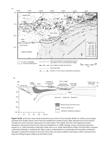
Figure 10.28 (a) Tectonic map and (b) interpretive cross-section of the Australia–Banda arc collision zone (images
provided by M. Audley-Charles and R. Hall and modified from Audley-Charles, 2004, with permission from Elsevier).
Triangles are active volcanoes. Hypocenters for events below 75 km depth show the north-dipping Australian
lithospheric slab and are based on the data set of Engdahl et al. (1998). Geologic section incorporates data from
Hughes et al. (1996), Richardson & Blundell (1996), Harris et al. (2000), Hall & Wilson (2000), and Hall (2002). Australian
continental shelf edge is marked by the 200 m contour. Dotted pattern in (a) illustrates that Australian continental
lithosphere underlies the islands of Savu, Roti, Timor, Moa, Sermata and Babar. Shelf edge at 5 Ma is estimated from
Deep Sea Drilling Program drilling site 262 (black circle).