
Page 355 - Global Tectonics
P. 355
338 CHAPTER 10
(a) 140
0 500 Strike-slip fault Thrust front
135
NS km Subduction Seismic profiles
60 AX Whitehorse 130
AX
AX
YT
YT
Y Y Denali Fault YT YT 125 120
YT
YT
CH CA SM 115 110 Outer Terranes Intermontane Terranes
CH
CH
CC
Nahanni Nahanni Nahanni Hottah Hottah Hottah
SM CH Chugach ST Stikinia
CH
CH
Fort Simpson
Fort Simpson
CR
CR
GSL Shear Zone
GSL Shear Zone
Transition
CA Tintina Fault Fort Simpson 60 CR Crescent SM Slide Mountain
Fault
Fort
OL
OL
55 Nelson GSL Shear Zone Taltson OL Olympic CC Cache Creek
Pacific Rim
Quesnellia
PR
PR
PR
QN
Taltson
Taltson
AX
AX Coast Shear Zone QN Y Y Yakutat BR Bridge River
AX
Buffalo
Buffalo
Stikinia Fold & Thrust Belt Buffalo
Head
Head
Head
Prince Insular Terranes CA–MT Cadwallader-Methow
Prince
Queen Charlotte
Rupert
Rupert
Fairweather Fault
PACIFIC WR CC AX Alexander
WR
WR
AX
AX
Coast Shear Zone
Coast Shear Zone
PLATE 55 E Easton and Melange
WR Wrangellia
WR
WR
AX
AX HA Harrison-Nooksack
AX
Fraser Fault QN Rocky Mountain Trench Undivided Preicratonic Terranes
Edmonton
50 Edmonton Plutonics and
KO
KO
-
O
KO-YT
Y
Yukon-Tanana
CD KO Metamorphics K KO-YT T Kootenay
MO
MO
BR MO MO Monshee
MO
MO
Calgary
WR Calgary Displaced
WR
WR
Hearne
Hearne
HA Hearne Continental Margin North American
50 Foreland fold Ancestral Basement
MT QN and thrust Proterozoic
OL CR
OL
OL
CR PR
CR PRPR
JUAN CA Cassiar
DE FUCA 125 Seattle Archean
PLATE SC-FF 120 NS Nisling
115 110
(b) PACIFIC INSULAR COAST BELT INTERMONTANE OMINECA FORELAND
Pacific Plate Wrangellia AXAX Coast Plutonic Complex Stikinia CC CA SM Cassiar KO-YT North American Miogeocline Nahanni
Nahanni
Wrangellia
Queen Charlotte Coast Shear
Fairweather Fault Zone Kechika Tintina Muskwa W. Canada
Fort
Queen Charlotte Prince Bowser Basin Stiknie Arch ? Fault Fault Watson Anticlinorium Sed. Basin Nelson
0 Pacific Ocean QCT Islands Hecate Strait Rupert Coast Plutonic Complex Stewart Stikinia Dease Lake Lake 0 20
Coast Plutonic Complex
Pacific Crust
CC
Wrangellia/Alexander
Wrangellia/Alexander
Depth (km) 40 Lithospheric Mantle ?? North American Lithospheric Mantle ? North American Lithospheric Mantle MOHO 40 Depth (km)
20
Pacific Plate
Pacific Plate
?
MOHO
MOHO
Lithospheric Mantle
North American Lithospheric Mantle
60
60
North American Lithospheric Mantle
80
Asthenosphere
VE 1:1
100
100 Asthenosphere VE 1:1 80
0 100 200 300 400 500 600 700 800 900 1000 1100 1200 1300
Queen Charlotte Distance (km)
Traverse SNORCLE 2A/22 SNORCLE 2B/21
ACCRETE
(c) PACIFIC INSULAR COAST BELT INTERMONTANE OMINECA FORELAND CRATON
Juan de Fuca Plate Wrangellia Plutonic Complex HA CD HA BR SB Quesnellia Kootenay Fold and Thrust Belt
Wrangellia
Cascadia Megathrust Garibaldi Volcanic Belt Fraser Fault Nicola Horst Vernon Slocan Lake Rocky Mtn Thrust and Western Canada
Juan de Fuca Interface WCF Antiform FaultF Trench Fold Belt Sedimentary Basin
0 Ridge Pacific Ocean Vancouver Island Vancouver Okanagan L. Monashees Purcells Rockies 0
Wrangellia
20 Juan de Fuca Lithospheric Mantle Wrangellia MOHO North American Ancestral Basement 20
North American Ancestral Basement
Depth (km) 40 Asthenosphere Serpentinized North American Lithospheric Mantle Lithospheric Mantle 60 Depth (km)
40
North American Lithospheric Mantle
Serpentinized
MOHO
MOHO
Mantle
Mantle
60
Juan de Fuca Lithospheric Mantle
Asthenosphere
North American
North American
80
80
Asthenosphere
Lithospheric Mantle
100
120
120 ? VE 1:1 100
0 100 200 300 400 500 600 700 800 900 1000 1100 1200 1300
Distance (km)
SOUTHERN CORDILLERA TRANSECT
ALBERTA
OFFSHORE SURVEYS SHIPS BASEMENT
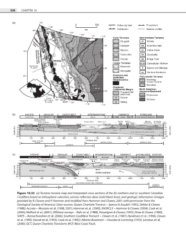
Figure 10.33 (a) Tectonic terrane map and interpreted cross-sections of the (b) northern and (c) southern Canadian
Cordillera based on lithospheric velocities, seismic reflection data (solid black lines), and geologic information (images
provided by R. Clowes and P. Hammer and modified from Hammer and Clowes, 2007, with permission from the
Geological Society of America). Data sources: Queen Charlotte Traverse – Spence & Asudeh (1993), Dehler & Clowes
(1988); Accrete – Morozov et al. (1998, 2001), Hammer et al. (2000); SNORCLE – Hammer & Clowes (2004), Cook et al.
(2004), Welford et al. (2001); Offshore surveys – Rohr et al. (1988), Hasselgren & Clowes (1995), Drew & Clowes (1990);
SHIPS – Ramachandran et al. (2006); Southern Cordillera Transect – Clowes et al. (1987), Hyndman et al. (1990), Clowes
et al. (1995), Varsek et al. (1993), Cook et al. (1992); Alberta Basement – Chandra & Cumming (1972), Lemieux et al.
(2000). QCT, Queen Charlotte Transform; WCF, West Coast Fault.