
Page 38 - Global Tectonics
P. 38
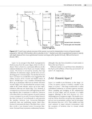
THE INTERIOR OF THE EARTH  25


            Figure 2.17  P and S wave velocity structure of the oceanic crust and its interpretation in terms of layered models
                                                         −1
            proposed in 1965 and 1978. Numbers refer to velocities in km s . Dashed curve refers to gradational increase in velocity
            with depth deduced from more sophisticated inversion techniques (after Spudich & Orcutt, 1980 and Harrison &
            Bonatti, 1981).


               Layer 1 is on average 0.4 km thick. It progressively   although it has also been identified as basalt similar to

            thickens away from the ocean ridges, where it is thin or   that at the top of layer 2.

            absent. There is, however, a systematic difference in the   Reflectors similar to A and B have been identifi ed in
            sediment thicknesses of the Pacifi c and Atlantic/Indian   the Pacific and Caribbean, where they are termed A′, B′

            oceans. The former is rimmed by trenches, that trap   and A″, B″, respectively.
            sediments of continental origin, and the latter are not,
            allowing greater terrestrial input. The interface between
            layer 1 and layer 2 is considerably more rugged than the
            seabed, because of the volcanic and faulted nature of   2.4.6  Oceanic layer 2
            layer 2. Within layer 1 are a number of horizons that
            show up as prominent reflectors on seismic refl ection   Layer 2 is variable in its thickness, in the range 1.0–

            records. Edgar (1974) has described the acoustic stratig-  2.5 km. Its seismic velocity is similarly variable in the
                                                                       −1
            raphy in the North Atlantic, where up to four supra-  range 3.4–6.2 km s . This range is attributable to either
            basement reflectors are found (Fig. 2.18). Horizon A   consolidated sediments or extrusive igneous material.

            corresponds to an Eocene chert, although deep sea drill-  Direct sampling and dredging of the sediment-free
            ing indicates that it maintains its refl ective  character   crests of ocean ridges, and the necessity of a highly
            even when little or no chert is present. In such locations   magnetic lithology at this level (Section 4.2), over-
            it may correspond to an early Cenozoic hiatus beneath   whelmingly prove an igneous origin. The basalts recov-
            the chert. Horizon A* occurs beneath A, and represents   ered are olivine tholeiites containing calcic plagioclase,
            the interface between Late Cretaceous/Paleogene   and are poor in potassium, sodium, and the incompat-
            metal-rich clays and underlying euxinic black clays.   ible elements (Sun et al., 1979). They exhibit very little
            Horizon B represents the base of the black clays, where   areal variation in major element composition, with
            they overlie a Late Jurassic/Lower Cretaceous lime-  the exception of locations close to oceanic islands
            stone. Horizon B may represent a sedimentary horizon,   (Section 5.4).