
Page 384 - Global Tectonics
P. 384
366 CHAPTER 11
Time (s)
E 0 5 10 15 20 25 30
12000 40
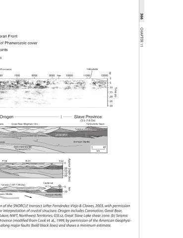
Yellowknife 11000 Slave Province (3.5–2.6 Ga) Yellowknife Basin Upper crust Upper crust Archean Mantle 0 km
10000 Approx Depth (km) km 30
70
30
50
Lower crust Lower crust East 0 0
90
Rae ?
9000 Archean Mantle
Calderian
Moho
Moho
?
8000
B-41
Cordilleran Front Extent of Phanerozoic cover Shot points 300 Ft. Providence 7000 6000 Wopmay Orogen Great Bear Magmatic Arc Hottah Terrane Upper crust Upper crust Lower crust Lower crust ? Hottah Mantle Archean and/or Proterozoic Deformed Mantle Deformed Mantle Proterozoic (?) Proterozoic (?) P-56 Hottah–Great Bear Terrane (1.92–1.85 Ga) Archean and/or Proterozoic Mantle (a) Map showing tectonic elements of the Wopmay Orogen and location of the SNORCLE transect (after Fernández-Viejo & Clowes, 2003, with permi
0 km Junction Hwy. 1 & 3 5000 cal Union. Copyright © 1999 American Geophysical Union). Reconstruction is made along major faults (bold black lines) and shows a minimum estimate.
60 4000 West
63 Underthrusted lower crust of Fort Simpson
Rae 111
Contwoyto Fort Simpson Accretion
1100 Yellowknife 1101 Taltson 114 3000 Fort Simpson Terrane
Anton Slp. Dragon 1104 A 1105 1107 GSLsz Buffalo Head Lower crust Lower crust Proterozoic mantle of Fort Simpson Terrane and Basin
Great Bear B 117 2000 Upper crust Upper crust ~400 km convergence minimum
Coronation
1108 AB Terrane (1.85–0.6 Ga)
Hottah C BC 120 Ft. Simpson Fort Simpson
1110 Moho rise due to Middle Proterozoic extension
Fort Simpson
D 1000
CANADA 1112 NWT 123 Cordillera Phanerozoic Phanerozoic Proterozoic Mantle
Nahanni butte Nahanni 100 km
Cordillera YK
1113 126 W 0 15 30 50 70 90 110
5
0
10 15 20 25 30 Approx. Depth (km)
(a) (b) Time (s) (c) (d)
Fig. 11.15