
Page 68 - Global Tectonics
P. 68
CONTINENTAL DRIFT 55
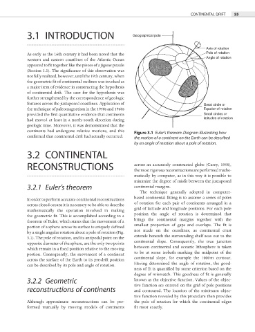
3.1 INTRODUCTION Geographical pole
Axis of rotation
Pole of rotation
As early as the 16th century it had been noted that the
Angle of rotation
western and eastern coastlines of the Atlantic Ocean
appeared to fit together like the pieces of a jigsaw puzzle
(Section 1.1). The significance of this observation was
not fully realized, however, until the 19th century, when
the geometric fit of continental outlines was invoked as
a major item of evidence in constructing the hypothesis
of continental drift. The case for the hypothesis was
further strengthened by the correspondence of geologic
features across the juxtaposed coastlines. Application of Great circle or
the technique of paleomagnetism in the 1950s and 1960s Equator of rotation
provided the fi rst quantitative evidence that continents Small circles or
had moved at least in a north–south direction during latitudes of rotation
geologic time. Moreover, it was demonstrated that the
continents had undergone relative motions, and this
Figure 3.1 Euler’s theorem. Diagram illustrating how
confirmed that continental drift had actually occurred. the motion of a continent on the Earth can be described
by an angle of rotation about a pole of rotation.
3.2 CONTINENTAL
RECONSTRUCTIONS across an accurately constructed globe (Carey, 1958),
the most rigorous reconstructions are performed mathe-
matically by computer, as in this way it is possible to
minimize the degree of misfit between the juxtaposed
3.2.1 Euler’s theorem continental margins.
The technique generally adopted in computer-
based continental fitting is to assume a series of poles
In order to perform accurate continental reconstructions
of rotation for each pair of continents arranged in a
across closed oceans it is necessary to be able to describe
mathematically the operation involved in making grid of latitude and longitude positions. For each pole
position the angle of rotation is determined that
the geometric fit. This is accomplished according to a
theorem of Euler, which states that the movement of a brings the continental margins together with the
smallest proportion of gaps and overlaps. The fi t is
portion of a sphere across its surface is uniquely defi ned
by a single angular rotation about a pole of rotation (Fig. not made on the coastlines, as continental crust
extends beneath the surrounding shelf seas out to the
3.1). The pole of rotation, and its antipodal point on the
opposite diameter of the sphere, are the only two points continental slope. Consequently, the true junction
between continental and oceanic lithosphere is taken
which remain in a fixed position relative to the moving
portion. Consequently, the movement of a continent to be at some isobath marking the midpoint of the
continental slope, for example the 1000 m contour.
across the surface of the Earth to its pre-drift position
Having determined the angle of rotation, the good-
can be described by its pole and angle of rotation.
ness of fit is quantified by some criterion based on the
degree of mismatch. This goodness of fi t is generally
3.2.2 Geometric known as the objective function. Values of the objec-
tive function are entered on the grid of pole positions
reconstructions of continents and contoured. The location of the minimum objec-
tive function revealed by this procedure then provides
Although approximate reconstructions can be per- the pole of rotation for which the continental edges
formed manually by moving models of continents fit most exactly.