
Page 191 - Handbook of Gold Exploration and Evaluation
P. 191
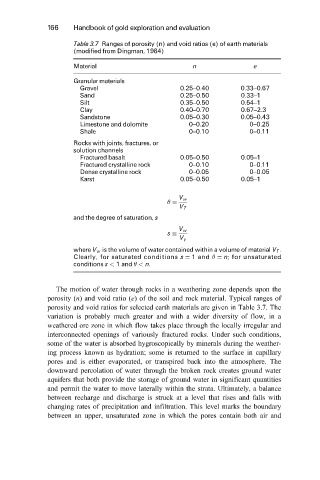
166 Handbook of gold exploration and evaluation
Table 3.7 Ranges of porosity (n) and void ratios (e) of earth materials
(modified from Dingman, 1984)
Material n e
Granular materials
Gravel 0.25±0.40 0.33±0.67
Sand 0.25±0.50 0.33±1
Silt 0.35±0.50 0.54±1
Clay 0.40±0.70 0.67±2.3
Sandstone 0.05±0.30 0.05±0.43
Limestone and dolomite 0±0.20 0±0.25
Shale 0±0.10 0±0.11
Rocks with joints, fractures, or
solution channels
Fractured basalt 0.05±0.50 0.05±1
Fractured crystalline rock 0±0.10 0±0.11
Dense crystalline rock 0±0.05 0±0.05
Karst 0.05±0.50 0.05±1
V w
V T
and the degree of saturation, s
V w
s
V y
where V w is the volume of water contained within a volume of material V T .
Clearly, for saturated conditions s 1 and n; for unsaturated
conditions s < 1 and < n.
The motion of water through rocks in a weathering zone depends upon the
porosity (n) and void ratio (e) of the soil and rock material. Typical ranges of
porosity and void ratios for selected earth materials are given in Table 3.7. The
variation is probably much greater and with a wider diversity of flow, in a
weathered ore zone in which flow takes place through the locally irregular and
interconnected openings of variously fractured rocks. Under such conditions,
some of the water is absorbed hygroscopically by minerals during the weather-
ing process known as hydration; some is returned to the surface in capillary
pores and is either evaporated, or transpired back into the atmosphere. The
downward percolation of water through the broken rock creates ground water
aquifers that both provide the storage of ground water in significant quantities
and permit the water to move laterally within the strata. Ultimately, a balance
between recharge and discharge is struck at a level that rises and falls with
changing rates of precipitation and infiltration. This level marks the boundary
between an upper, unsaturated zone in which the pores contain both air and