
Page 288 - Handbook of Gold Exploration and Evaluation
P. 288
254 Handbook of gold exploration and evaluation
4.5.3 Quaternary adjusted deposits
Quaternary adjustments of river systems resulting from changes in annual
precipitation and episodes of glaciation and deglaciation have widely modified
the characteristics of most present-day river systems from those of their parent
river systems. Tertiary climates were predominantly hotter, more humid and
precipitation was much higher than today hence, in most cases the ancestral
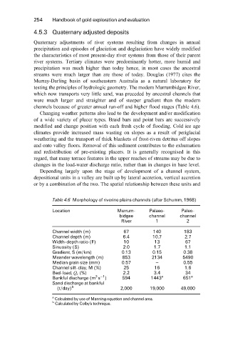
streams were much larger than are those of today. Douglas (1977) cites the
Murray-Darling basin of southeastern Australia as a natural laboratory for
testing the principles of hydrologic geometry. The modern Murrumbidgee River,
which now transports very little sand, was preceded by ancestral channels that
were much larger and straighter and of steeper gradient than the modern
channels because of greater annual run-off and higher flood stages (Table 4.6).
Changing weather patterns also lead to the development and/or modification
of a wide variety of placer types. Braid bars and point bars are successively
modified and change position with each fresh cycle of flooding. Cold ice age
climates provide increased mass wasting on slopes as a result of periglacial
weathering and the transport of thick blankets of frost-riven detritus off slopes
and onto valley floors. Removal of this sediment contributes to the exhumation
and redistribution of pre-existing placers. It is generally recognised in this
regard, that many terrace features in the upper reaches of streams may be due to
changes in the load-water discharge ratio, rather than in changes in base level.
Depending largely upon the stage of development of a channel system,
depositional units in a valley are built up by lateral accretion, vertical accretion
or by a combination of the two. The spatial relationship between these units and
Table 4.6 Morphology of riverine plains channels (after Schumm, 1968)
Location Murrum- Palaeo- Paleo-
bidgee channel channel
River 1 2
Channel width (m) 67 140 183
Channel depth (m) 6.4 10.7 2.7
Width-depth ratio (F) 10 13 67
Sinuosity (S) 2.0 1.7 1.1
Gradient, S (m/km) 0.13 0.15 0.38
Meander wavelength (m) 853 2134 5490
Median grain size (mm) 0.57 ± 0.55
Channel silt-clay, M (%) 25 16 1.6
Bed-load, Q s (%) 2.2 3.4 34
3 ÿ1
Bankful discharge (m s ) 594 1443 a 651 a
Sand discharge at bankful
(t/day) b 2,000 19,000 49,000
a Calculated by use of Manning equation and channel area.
b Calculated by Colby's technique.