
Page 38 - Hydrocarbon Exploration and Production Second Edition
P. 38
Exploration 25
Eventually, only the drilling of an exploration well will prove the validity of the
concept. A ‘wildcat’ well is drilled in a region with no prior well control. Wells
either result in discoveries of oil and gas, or they find the objective zone to be
water-bearing in which case they are termed ‘dry’.
Exploration activities are potentially damaging to the environment. The cutting
down of trees in preparation for an onshore seismic survey may result in severe soil
erosion in years to come. Offshore, fragile ecological systems such as reefs can be
permanently damaged by spills of crude or mud chemicals. Responsible companies will
therefore carry out an environmental impact assessment (EIA) prior to activity planning
and draw up contingency plans should an accident occur. In Chapter 5, a more detailed
description of health, safety and environmental considerations will be provided.
3.2.1. Introduction to geophysical methods
There are various geophysical surveying methods that are routinely applied in the
search for potential hydrocarbon accumulations. Geophysical methods respond to
variations in physical properties of the earth’s subsurface including its rocks, fluids
and voids. They locate boundaries across which changes in properties occur. These
changes give rise to an anomaly relative to a background value; this anomaly is the
target which the methods are trying to detect.
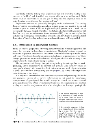
The measurement of changes in signal strength along lines of a grid or network,
‘profiling’, allows anomalies to be mapped out spatially. Care should be taken to
avoid spatial ‘aliasing’, the loss of fine detail information as a result of gathering data
at only a small number of measuring stations (Figure 3.6). Time and budget often
come into play at this stage.
It is important to remember that the mere acquisition and processing of data do
not guarantee success of a survey: information is not equal to knowledge.
Interpretation of geophysical data should always be carried out within a sound
geological framework. Often several methods are used to complement one another
or they are used in conjunction with other disciplines to develop a geologically
If the sample frequency is high
e.g. measuring at times marked
amplitude by a cross, then the wave is
sampled adequantely with faithful
representation of the input data.
If the sample frequency is low
e.g. measuring at times marked
amplitude by a circle, then the wave is
sampled inadequantely with loss
of the high frequency information
and distortion of the input data.
Figure 3.6 Loss of information due to limited number of measurement points.