
Page 59 - Hydrocarbon Exploration and Production Second Edition
P. 59
46 Exploration Methods and Techniques
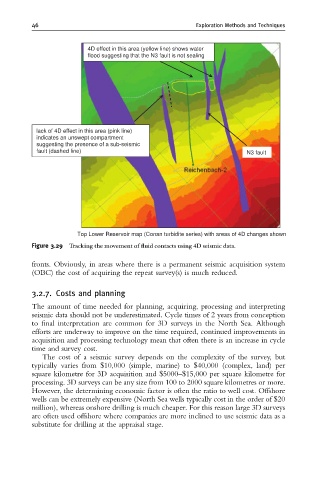
4D effect in this area (yellow line) shows water
flood suggesting that the N3 fault is not sealing
lack of 4D effect in this area (pink line)
indicates an unswept compartment
suggesting the presence of a sub-seismic
fault (dashed line) N3 fault
Top Lower Reservoir map (Conan turbidite series) with areas of 4D changes shown
Figure 3.29 Tracking the movement of £uid contacts using 4D seismic data.
fronts. Obviously, in areas where there is a permanent seismic acquisition system
(OBC) the cost of acquiring the repeat survey(s) is much reduced.
3.2.7. Costs and planning
The amount of time needed for planning, acquiring, processing and interpreting
seismic data should not be underestimated. Cycle times of 2 years from conception
to final interpretation are common for 3D surveys in the North Sea. Although
efforts are underway to improve on the time required, continued improvements in
acquisition and processing technology mean that often there is an increase in cycle
time and survey cost.
The cost of a seismic survey depends on the complexity of the survey, but
typically varies from $10,000 (simple, marine) to $40,000 (complex, land) per
square kilometre for 3D acquisition and $5000–$15,000 per square kilometre for
processing. 3D surveys can be any size from 100 to 2000 square kilometres or more.
However, the determining economic factor is often the ratio to well cost. Offshore
wells can be extremely expensive (North Sea wells typically cost in the order of $20
million), whereas onshore drilling is much cheaper. For this reason large 3D surveys
are often used offshore where companies are more inclined to use seismic data as a
substitute for drilling at the appraisal stage.