
Page 70 - Hydrogeology Principles and Practice
P. 70
HYDC02 12/5/05 5:38 PM Page 53
Physical hydrogeology 53
BO X
Land subsidence in the Central Valley, California
2.8
Agricultural production in the Central Valley of California is depend- largest volume of land subsidence in the world due to groundwater
ent on the availability of water for irrigation. One-half of this abstraction. Land subsidence has caused problems such as cracks in
irrigation water is supplied by groundwater and accounts for 74% roads and canal linings, changing slopes of water channels and rup-
of California’s total abstractions and about 20% of the irriga- tured well casings.
tion abstractions in the United States (Williamson et al. 1989). From pre-development until 1977, the volume of water in aquifer
9
3
3
9
Groundwater abstraction is especially important in dry years when storage declined by about 74 × 10 m , with 49 × 10 m from the
9
3
it supplements highly variable surface water supplies. In 1975, water table zone, 21 × 10 m from inelastic compaction of fine-
9
6
3
about 57% of the total land area (5.2 × 10 ha) in the Central grained sediments and 4 × 10 m from elastic storage. Elastic stor-
Valley was irrigated. The intensive agricultural development during age is a result of the expansion of water and the compression of
the past 100 years has had major impacts on the aquifer system. sediments resulting from a change in fluid pressure (see Section
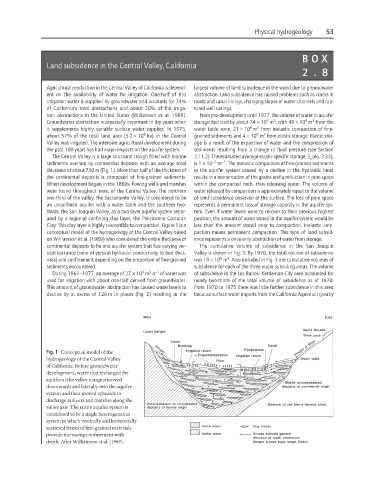
The Central Valley is a large structural trough filled with marine 2.11.2). The estimated average elastic specific storage, S (eq. 2.33),
s
−5
−1
sediments overlain by continental deposits with an average total is 1 × 10 m . The inelastic compaction of fine-grained sediments
thickness of about 730 m (Fig. 1). More than half of the thickness of in the aquifer system caused by a decline in the hydraulic head
the continental deposits is composed of fine-grained sediments. results in a reorientation of the grains and a reduction in pore space
When development began in the 1880s, flowing wells and marshes within the compacted beds, thus releasing water. The volume of
were found throughout most of the Central Valley. The northern water released by compaction is approximately equal to the volume
one-third of the valley, the Sacramento Valley, is considered to be of land subsidence observed at the surface. The loss of pore space
an unconfined aquifer with a water table and the southern two- represents a permanent loss of storage capacity in the aquifer sys-
thirds, the San Joaquin Valley, as a two-layer aquifer system separ- tem. Even if water levels were to recover to their previous highest
ated by a regional confining clay layer, the Pleistocene Corcoran position, the amount of water stored in the aquifer system would be
Clay. This clay layer is highly susceptible to compaction. Figure 1 is a less than the amount stored prior to compaction. Inelastic com-
conceptual model of the hydrogeology of the Central Valley based paction means permanent compaction. This type of land subsid-
on Williamson et al. (1989) who considered the entire thickness of ence represents a once-only abstraction of water from storage.
continental deposits to be one aquifer system that has varying ver- The cumulative volume of subsidence in the San Joaquin
tical leakance (ratio of vertical hydraulic conductivity to bed thick- Valley is shown in Fig. 3. By 1970, the total volume of subsidence
9
3
ness) and confinement depending on the proportion of fine-grained was 19 × 10 m . Also included in Fig. 3 are cumulative volumes of
sediments encountered. subsidence for each of the three major subsiding areas. The volume
3 −1
9
During 1961–1977, an average of 27 × 10 m a of water was of subsidence in the Los Banos–Kettleman City area accounted for
used for irrigation with about one-half derived from groundwater. nearly two-thirds of the total volume of subsidence as of 1970.
This amount of groundwater abstraction has caused water levels to From 1970 to 1975 there was little further subsidence in this area
decline by in excess of 120 m in places (Fig. 2) resulting in the because surface water imports from the California Aqueduct greatly
Fig. 1 Conceptual model of the
hydrogeology of the Central Valley
of California. Before groundwater
development, water that recharged the
aquifer at the valley margins moved
downwards and laterally into the aquifer
system and then moved upwards to
discharge at rivers and marshes along the
valley axis. The entire aquifer system is
considered to be a single heterogeneous
system in which vertically and horizontally
scattered lenses of fine-grained materials
provide increasing confinement with
depth. After Williamson et al. (1989).