
Page 38 - Laboratory Manual in Physical Geology
P. 38
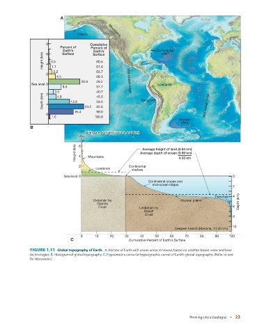
A


                                      Trench         Mountains

                       8                    Cumulative
                              Percent of     Percent of
                               Earth’s        Surface                       Continental
                                              Earth’s
                                                                              shelf
                      Height (km)  4  0.5      00.5
                               Surface
                       6
                          1.1
                           2.2                 01.6
                                               03.7
                       2
                            4.5                08.3
                                        20.9   29.2           Mid-ocean ridge
                Sea level 0                                                  Lowlands
                               8.5             37.7
                           3.0                 40.7                      Mountains
                      Depth (km)  4  4.8  13.9  23.2  45.5          Trench                         Mid-ocean ridge
                       2
                                               59.4
                                               82.6
                                     16.4      99.0
                       6
                          1.0                 100.0
                                                                                       Abyssal
                                                                                        plain
                B
                                          Highest mountain (Eve r
                                          Highest mountain (Ever
                                          Highest mountain (Everest, 8.85 km)est, 8.85 km)est, 8.85 km)
                                       8 8 8
                                     Height (km)  6 4  Mountains    Average depth of ocean (3.69 km)
                                                                     Average height of land (0.84 km)
                                                                                       4.53 km
                                       2                       Continental
                                               Lowlands         shelves
                                Sea level 0                                                                      0
                                                                        Continental slopes and
                                                                          mid-ocean ridges
                                                                                                                 2

                                                                                                        Trenches  4
                                              Underlain by                             Abyssal plains
                                               Granite                                                              Depth (km)
                                                Crust               Underlain by                                 6
                                                                      Basalt
                                                                      Crust
                                                                                                                 8
                                                                                                                10
                                                                                     Deepest trench (Mariana, 11.04 km)
                                        0     10      20     30     40     50     60      70     80     90     100
                                   C                           Cumulative Percent of Earth’s Surface


                 FIGURE 1.11    Global topography of Earth.            A.  Portion of Earth with ocean water removed, based on satellite-based radar and laser
               technologies.  B.  Histogram of global topography.  C.  Hypsometric curve (or hypsographic curve) of Earth’s global topography. (Refer to text
               for discussion.)


                                                                                            Thinking Like a Geologist   ■  23