
Page 403 - Laboratory Manual in Physical Geology
P. 403
A CTIVIT Y 14.3 Sand Seas of Nebraska and the Arabian Peninsula
Name: ____________________________ Course/Section: _____________________________ Date: ______________
N
0 1 2 3 4 5 km 0 1 2 3 miles
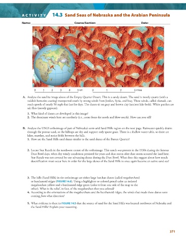
A. Analyze the satellite image above of the Empty Quarter Desert. This is a sandy desert. The sand is mostly quartz (with a
reddish hematite coating) transported south by strong winds from Jordan, Syria, and Iraq. These winds, called shamals, can
reach speeds of nearly 50 mph that last for days. The dunes sit on gray and brown clay (ancient lake beds). White patches are
salt flats (mostly gypsum).
1. What kind of dunes are developed in this image?
2. The dominant winds here are northerly (i.e., come from the north and blow south). How can you tell?
B. Analyze the USGS orthoimage of part of Nebraska’s semi-arid Sand Hills region on the next page. Rainwater quickly drains
through the porous sand, so the hilltops are dry and support only sparse grass. There is a shallow water table, so there are
lakes, marshes, and moist fields between the hills.
1. How are the Sand Hills sand dunes similar to the sand dunes of the Barren Quarter ?
2. Locate Star Ranch in the northwest corner of the orthoimage. This ranch was present in the 1930s during the famous
Dust Bowl days, when dry windy conditions persisted for years and dust storm after dust storm scoured the land here.
Star Ranch was not covered by any advancing dunes during the Dust Bowl. What does this suggest about how much
desertification must occur here in order for the large dunes of the Sand Hills to once again become an active sand sea?
3. The hills (Sand Hills) in the orthoimage are either large barchan dunes (called megabarchans )
or barchanoid ridges ( FIGURE 14.6 ). Using a highlighter or colored pencil color an isolated
megabarchan yellow and a barchanoid ridge green (color it from one side of the map to the
other). What is the relief, in feet, of the megabarchan that you colored?
4. According to the orientations of the megabarchans and the barchanoid ridges, the winds that made these dunes were
coming from what direction?
5. What evidence is there in FIGURE 14.5 that the source of sand for the Sand Hills was located northwest of Nebraska and
the Sand Hills? Explain your reasoning.
371