
Page 327 - Petroleum Geology
P. 327
297
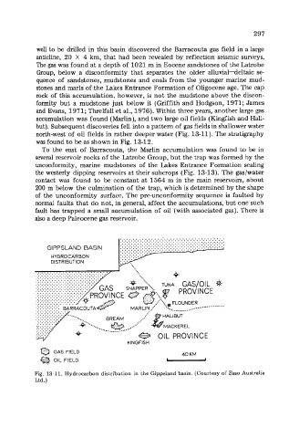
well to be drilled in this basin discovered the Barracouta gas field in a large
anticline, 20 X 4 km, that had been revealed by reflection seismic surveys.
The gas was found at a depth of 1021 m in Eocene sandstones of the Latrobe
Group, below a disconformity that separates the older alluvial-deltaic se-
quence of sandstones, mudstones and coals from the younger marine mud-
stones and mark of the Lakes Entrance Formation of Oligocene age. The cap
rock of this accumulation, however, is not the mudstone above the discon-
formity but a mudstone just below it (Griffith and Hodgson, 1971; James
and Evans, 1971; Threlfall et al., 1976). Within three years, another large gas
accumulation was found (Marlin), and two large oil fields (Kingfish and Hali-
but). Subsequent discoveries fell into a pattern of gas fields in shallower water
north-west of oil fields in rather deeper water (Fig. 13-11). The stratigraphy
was found to be as shown in Fig. 13-12.
To the east of Barracouta, the Marlin accumulation was found to be in
several reservoir rocks of the Latrobe Group, but the trap was formed by the
unconformity, marine mudstones of the Lakes Entrance Formation sealing
the westerly dipping reservoirs at their subcrops (Fig. 13-13). The gas/water
contact was found to be constant at 1564 m in the main reservoirs, about
200 m below the culmination of the trap, which is determined by the shape
of the unconformity surface. The pre-unconformity sequence is faulted by
normal faults that do not, in general, affect the accumulations, but one such
fault has trapped a small accumulation of oil (with associated gas). There is
also a deep Paleocene gas reservoir.
..................................
.................................
..................................
.................................
.................................
..................................
GIPPSLAND BASIN ..................................
HYDROCARBON
DISTRIBUTION
.................
.................
.................
.................
.................
.................
.................
.................
.................
....
.............
............. .. -. ................... .................
........
........
........
.... BREAM .......... HALIBUT
..... .......
OIL PROVINCE
KINGFISH -
0 FIELD 40 KM
GAS
OIL FIELD
Fig. 13-11. Hydrocarbon distribution in the Gippsland basin. (Courtesy of Esso Australia
Ltd.)