
Page 83 - Petroleum Geology
P. 83
sandstone at normal hydrostatic pressures acts as a drain to the water expelled
by compaction of the adjacent mudstones (Fig. 3-16). In general, therefore,
the pore water moves vertically across the bedding of the mudstones, then
laterally within the sandstone*.
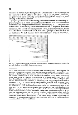
The geological context of abnormally pressured mudstones is dominantly re-
gressive sequences in which the sandstones tend to thicken towards the land
of the time, and wedge out in the seaward direction (Fig. 3-17). The geometry
of the drains therefore imposes a landward direction of migration within the
sandstones. The top of abnormal pressures tends, as Dickinson (1951,1953)
found for the Louisiana Gulf Coast, to become younger in the direction of
the regression. We shall examine these features in more detail in Chapter 14.
Fig. 3-17. Regional pore-water migration in sandstones of regressive sequences tends to be
towards the land from which the regression came.
* It is sometimes argued that mudstone pore water migrates laterally “because that is the
direction of greatest permeability”. We have seen that permeability is but one of the com-
ponents of fluid flow, and flow direction is determined by the direction of the fluid poten-
tial gradient. ‘fhe quantity of water flowing across a surface in unit time is proportional
to the area normal to flow and to the potential or hydraulic gradient (the loss of total
head divided by the length of the porous material in the direction of flow; Ahll). To get a
feel for the quantities and directions of compaction flow, consider a rectangular mass of
mudstone, 10 x 10 x 0.5 km, entirely surrounded by permeable sands at normal hydro-
static pressures. During compaction, the hydraulic gradient from a point in the centre of
the mudstone is x/0.25 vertically and x/5 horizontally - a factor of 20 in favour of ver-
tical flow. The two horizontal surface areas total 200 km2 ; the four vertical surfaces total
20 km2 - a factor of 10 in favour of vertical flow. So horizontal permeability would have
to be of the order of 200 times the vertical permeability for equal quantities to be lost
from the sides as from the top and bottom. In reality, mudstones tend to have lenticular
interfaces with sandstones (except at faults), and the ratio of thickness to lateral extent is
commonly much greater than that used in this simple model. There is no evidence that
anisotropy in mudstone permeability is anywhere near sufficient to lead to significant
quantities of lateral flow in mudstones.