
Page 157 - Planning and Design of Airports
P. 157
Air Traf fic Management 125
deemed sufficient to allow aircraft to navigate using properly
equipped GPS receivers for both en route navigation and approaches
to airports, in both VFR and IFR conditions.
In the first decade of the twenty-first century, the proliferation of
GPS-based air navigation systems has been dramatic, to the point
where the use of traditional ground-based navigation aids such as the
NDB and VOR is becoming obsolete. GPS navigation systems have
become available as both in-panel fixed navigation systems, and por-
table units, and have become widely used in many areas of society
outside of aviation.
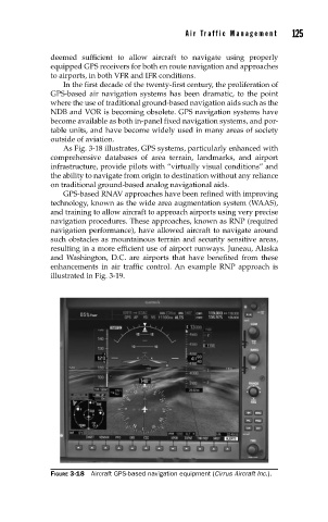
As Fig. 3-18 illustrates, GPS systems, particularly enhanced with
comprehensive databases of area terrain, landmarks, and airport
infrastructure, provide pilots with “virtually visual conditions” and
the ability to navigate from origin to destination without any reliance
on traditional ground-based analog navigational aids.
GPS-based RNAV approaches have been refined with improving
technology, known as the wide area augmentation system (WAAS),
and training to allow aircraft to approach airports using very precise
navigation procedures. These approaches, known as RNP (required
navigation performance), have allowed aircraft to navigate around
such obstacles as mountainous terrain and security sensitive areas,
resulting in a more efficient use of airport runways. Juneau, Alaska
and Washington, D.C. are airports that have benefited from these
enhancements in air traffic control. An example RNP approach is
illustrated in Fig. 3-19.
FIGURE 3-18 Aircraft GPS-based navigation equipment (Cirrus Aircraft Inc.).