
Page 153 - Plant-Based Remediation Processes
P. 153
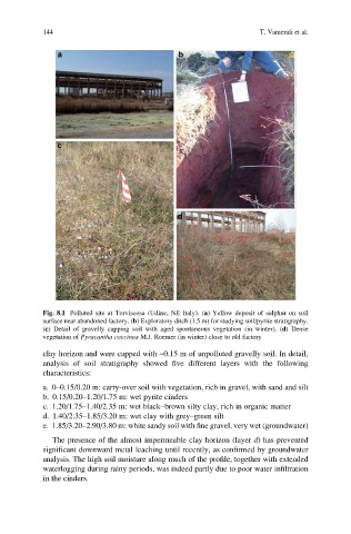
144                                                   T. Vamerali et al.


            Fig. 8.1 Polluted site at Torviscosa (Udine, NE Italy). (a) Yellow deposit of sulphur on soil
            surface near abandoned factory. (b) Exploratory ditch (1.5 m) for studying soil/pyrite stratigraphy.
            (c) Detail of gravelly capping soil with aged spontaneous vegetation (in winter). (d) Dense
            vegetation of Pyracantha coccinea M.J. Roemer (in winter) close to old factory

            clay horizon and were capped with ~0.15 m of unpolluted gravelly soil. In detail,
            analysis of soil stratigraphy showed five different layers with the following
            characteristics:
            a. 0–0.15/0.20 m: carry-over soil with vegetation, rich in gravel, with sand and silt
            b. 0.15/0.20–1.20/1.75 m: wet pyrite cinders
            c. 1.20/1.75–1.40/2.35 m: wet black–brown silty clay, rich in organic matter
            d. 1.40/2.35–1.85/3.20 m: wet clay with grey–green silt
            e. 1.85/3.20–2.90/3.80 m: white sandy soil with fine gravel, very wet (groundwater)
              The presence of the almost impermeable clay horizon (layer d) has prevented
            significant downward metal leaching until recently, as confirmed by groundwater
            analysis. The high soil moisture along much of the profile, together with extended
            waterlogging during rainy periods, was indeed partly due to poor water infiltration
            in the cinders.