
Page 25 - Soil and water contamination, 2nd edition
P. 25
12 Soil and Water Contamination
a. b.
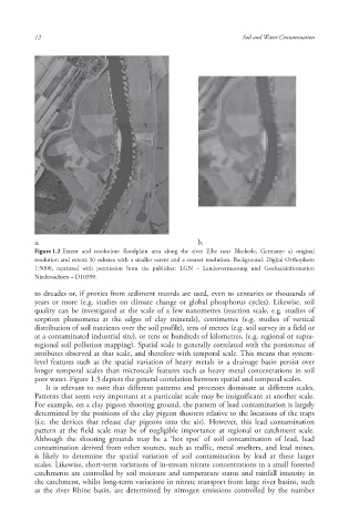
Figure 1.2 Extent and resolution : floodplain area along the river Elbe near Bleckede, Germany: a) original
resolution and extent; b) subarea with a smaller extent and a coarser resolution. Background: Digital Orthophoto
1:5000, reprinted with permission from the publisher: LGN – Landesvermessung und Geobasisinformation
Niedersachsen – D10390.
to decades or, if proxies from sediment records are used, even to centuries or thousands of
years or more (e.g. studies on climate change or global phosphorus cycles). Likewise, soil
quality can be investigated at the scale of a few nanometres (reaction scale, e.g. studies of
sorption phenomena at the edges of clay minerals ), centimetres (e.g. studies of vertical
distribution of soil nutrients over the soil profile ), tens of metres (e.g. soil survey in a field or
at a contaminated industrial site), or tens or hundreds of kilometres, (e.g. regional or supra-
regional soil pollution mapping). Spatial scale is generally correlated with the persistence of
attributes observed at that scale, and therefore with temporal scale. This means that system-
level features such as the spatial variation of heavy metals in a drainage basin persist over
longer temporal scales than microscale features such as heavy metal concentrations in soil
pore water. Figure 1.3 depicts the general correlation between spatial and temporal scales.
It is relevant to note that different patterns and processes dominate at different scales.
Patterns that seem very important at a particular scale may be insignificant at another scale.
For example, on a clay pigeon shooting ground, the pattern of lead contamination is largely
determined by the positions of the clay pigeon shooters relative to the locations of the traps
(i.e. the devices that release clay pigeons into the air). However, this lead contamination
pattern at the field scale may be of negligible importance at regional or catchment scale.
Although the shooting grounds may be a ‘hot spot’ of soil contamination of lead, lead
contamination derived from other sources, such as traffic, metal smelters, and lead mines,
is likely to determine the spatial variation of soil contamination by lead at these larger
scales. Likewise, short-term variations of in-stream nitrate concentrations in a small forested
catchments are controlled by soil moisture and temperature status and rainfall intensity in
the catchment, whilst long-term variations in nitrate transport from large river basins, such
as the river Rhine basin, are determined by nitrogen emissions controlled by the number
10/1/2013 6:44:03 PM
Soil and Water.indd 24
Soil and Water.indd 24 10/1/2013 6:44:03 PM