
Page 45 - Sumatra Geology, Resources and Tectonic Evolution
P. 45
32 CHAPTER 4
I I
104'~00 '
Quaternary Sediments
Qs QuaternaryVolcanics
Qv Ptiocene
Late Miocene
Middle Miocene
Oligo-Miocene
Qs Eocene
MARTAPURA~/-
9 , ...F .,
o., ,,,.
Qv
,J-'-: ~ ...............
,%
% % %, % %` %, % % % %, % % "-" .~ .., ..~ ,,,, ,,.. ,,.,. .,
% % "% % % % % % '% % "%"-."'%"'%~" " t'~ . . . . . . F
,/,'...'Garba Pluton,",",,'%.'~ ,, ~,, ~ ~x@~. Qs
% % % % % "% % "% "% % % % ~. -,,,,,..w, '~ "." "-" "-"
~.O.O,Or
.Y ." ,' ," ,' ." ,' ,' ,' ,' -" ,' .rdununq A ,_~ F Faults
Late Cretaceous Granites
i : ~ } ~";"-"-"-"-"-~','.~-" ::: :: ~ " - "'," -'," -',",,.'~ Mesozoic Units
(correlated with the Woyla Group)
4o30 ,
.... Mm 9 ~ Melange
Qs Situlanglang (chert) Member
Garba (volcanic) Formation
0 5 10 t5 20km QS ~-""----__~J~Ev'/ Tarap Formation
' ~ (metamorphosed ?Palaeozoics)
I I
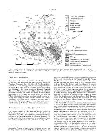
Fig. 4.7. The distribution of the Pre-Tertiary units in the Garba Mountains, South Sumatra, after GRDC geological map of Baturaja (Gafoer et al. 1994). The
Metamorphosed Palaeozoics are correlated with the Tapanuli Group and the Garba and Situlanglang Formations are correlated with the Jurassic-Cretaceous Woyla Group
of northern Sumatra (see below).
Pemali Group, Bangka Island not yet proved possible to determine the stratigraphic relationships
of the units which make up the Tapanuli Group. The Vis~an
Carboniferous-Permian rocks of the Pemali Group occur Alas Formation and Limestone Member of the Kuantan Formation
on Bangka Island where they are imbricated with the Triassic are the only units for which there is direct palaeontological
Tempilang Sandstones (Ko 1986) (Fig. 4.2). The Pemali Group evidence of age. The Bohorok and Kluet/Kuantan formations
occurs in east-west trending, fault-bounded outcrops throughout have also been regarded as of Carboniferous age because of their
the island. Rock types include isoclinally folded pyritic shales close association with the Alas and Kuantan limestones in the
and limestones, the latter containing Permian fusulinids field, and because all three formations contain similar lithologies,
(De Roever 1951), volcanics and bedded cherts, with radiolaria, and in general show the same degree of deformation. The presence
laminated mudstones and pebbly mudstones. According to the of fossils indicating an age near the Devonian-Carboniferous
description by Ko (1986) the pebbly mudstones from the boundary in a borehole in the Malacca Strait (Eubank & Makki
Toboali District in the southern part of the island resemble very 1981), the identification of Late Carboniferous-Early Permian
closely those already described from the Bohorok and Mentulu fossils in the Pangururan Bryozoan Bed (AIdiss et al. 1983)
formations, above, and contain clasts with a similar range of suggests that the Tapanuli Group may cover an age range from
sizes and lithologies, although previously these same outcrops Late Devonian to Early Permian.
were described by De Roever (1951) as arkosic conglomerate. The BGS/DMR surveyors, who mapped the Tapanuli Group
as part of the North Sumatra Project, considered that all three
units were broadly contemporaneous. They observed that pebbly
Persing Complex, Singkep and the 'Quartzite Terrain' mudstones, characteristic of the Bohorok Formation, are inter-
bedded with quartz sandstones and pelitic sediments of turbidite
The Persing Complex of the island of Singkep consists of facies. These turbiditic sediments, with variations in the pro-
phyllite, slate, graphitic schists with quartz veins and bands of quart- portions of the components, are the dominant lithoiogies in the
zite (Sutisna et al. 1994). The quartzites are compared lithologically Kluet and Kuantan formations and also in the Tigapuluh Group
with those of the Tarantam Formation in the Duablas Mountains. The of Central Sumatra. Cameron et al. (1982a) report that, apart
Persing Complex lies along strike from the 'Quartzite Terrain' ident- from the presence or absence of pebbly mudstones, the lithologies
ified in oil company boreholes in the Pekanbaru area (Fig. 4.2). of the Bohorok and Kluet formations are so similar that the bound-
ary between them on the Medan Sheet was drawn arbitrarily
because of the difficulty in distinguishing between the two units.
Interpretation The outcrop of the Alas Formation is interposed between the
Bohorok and Kluet formations (Figs 4.2 & 4.3). As reported
Stratigraphy. Because of poor exposure, scattered outcrops and above a Vis6an (Lower Carboniferous) age has been established
the large numbers of faults which disrupt the sequence, it has for the Alas Formation (Fontaine 1989; Metcalfe 1983). A