
Page 63 - Sumatra Geology, Resources and Tectonic Evolution
P. 63
50 CHAPTER 4
..N'.'.'.'.'.'103._.~j) 104 ~ ~ 105 ~ 106 ~
. . . . . . . . "o " '" , , I
"Tigapuiuh~
"
PADANG Mountainsl i i i i...~L~
-1 ~ ,i,i-i-i-i-i,i..--> . 0 50 100km
I
9 ........_ .o.7.2\
9 ...........#1.o.
! B] (,bj,
:" :" :.".
i ::@:;i:~,~ . . . . . . ;, O e? g/'}'rio0 BANGKA
}
.Mountain ~ i~'':':''';:-:':'i'~ ~ :::'~
. . . . . . .
.
.
.
.
.
.
Formation ~%'--"". ,_'",_'\"N ~.. "..~. ',:":':'i:":'i'::'s O:'''...j
,o \ au,ts
Taboali
NIK N Thrusts
JURASSIC - MID-CRETACEOUS (Woyla Grot
~ Sepintiang, kingsing, Saling, Situlangang, i
Garba and Menanga Formations q
MID-JURASSIC - EARLY CRETACEOUS
~ Tabir, Rawas and Peneta Formations
PERMO-TRIASSIC
Pemali, Tempilang, Papan, Kualu,
Tuhur and Silungkang Formations
EARLY PERMIAN (PEUSANGAN GROUP)
[ ~ Palepat and Mengkarang Formations
CARBONIFEROUS - ?EARLY PERMIAN (TAPANULI GROUP)
Kuantan Formation
Mentulu (Bohorok) Formation
Squares, circles and triangles indicate units encountered in boreholes 104~ ~i~ 105~ ~ 106~
I -v\ I I
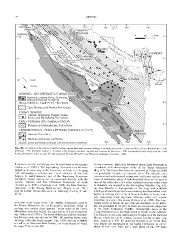
Fig. 4.18. Distribution of the subcrop of the Pre-Tertiary stratigraphic units in southern Sumatra, including the Jurassic-Cretaceous Woyla Group. Borehole data is from
De Coster (1974). Boreholes marked 'L' bottomed in the 'Kluang Limestone' regarded as Cretaceous by De Coster (1974), but considered more likely to be part of the
Kuantan Formation in this account. The distribution of Permian (P) and Triassic (Tr) units on Bangka is from Ko (1986).
Limestone and the underlying units is considered to be tectonic Garba Formation. The Garba Formation in the Garba Mountains is
(Gafoer et al. 1992c). The Sepingtiang Limestone may be inter- associated with metamorphic rocks of the Tarap Formation
preted in the same way as the limestones in Aceh, as a fringing (Fig. 4.7). The Garba Formation is composed of (?)amygdaloidal
reef surrounding a volcanic arc. Fossil evidence of the Late and porphyritic basaltic and andesitic lavas. The volcanic rocks
Jurassic to mid-Cretaceous age of the Sepintiang Limestone are associated with sheared serpentinite and lenses and intercala-
Formation means that it can be correlated directly with the tions of radiolarian chert. A fault-bounded sliver on the eastern
Lamno, Teunom and Sise Limestone formations of Aceh side of the inlier, and a few other scattered outcrops where chert
(Bennett et al. 1981a; Cameron et al. 1983), the Batu Nabontar is abundant, are mapped as the Situlanglang Member (Fig. 4.7).
limestones in the Batang Natal section (Wajzer et al. 1991) An Insu Member is distinguished on the map, with a similar
and the Lubuk Peraku limestones at Indarung (Yancey & Alif lithological assemblage, but also containing interlayered lenticular
1977). bodies of m~lange ('m' in Fig. 4.7), with boulders of basalt, ande-
site, radiolarian chert, claystone, siltstone, schist and massive
limestone in a scaly clay matrix (Gafoer et al. 1994). The lime-
Intrusions in the Gumai Inlier. The Jurassic-Cretaceous units in stones found as blocks do not crop out elsewhere in the inlier,
the Gumai Mountains are cut by granitic intrusions, which by but are presumed to be derived from an unexposed component
analogy with similar dated granites further south in the Garba of the Garba Formation. Notably, metamorphic rocks of the
Mountains, described below, are regarded as of Late Cretaceous Tarap Formation have not been found as blocks in the melange.
age (Gafoer et al. 1992c). The rocks of the inlier and the surround- The foliation in the scaly matrix and the elongation of the enclosed
ing Tertiary rocks are also cut by NW-SE-trending faults, some blocks, which are cut by tension fractures normal to their long
showing strike-slip displacements (Fig. 4.19), and are evidently axes, trends in a NW-SE direction (Gafoer et al. 1994). Two
related to the Sumatran Fault System, the main strands of which fold phases are recognized in the Garba Formation, an earlier
lie some 25 km to the SW. phase of east-west folds and a later phase of NE-SW folds