
Page 120 - Synthetic Fuels Handbook
P. 120
106 CHAPTER FOUR
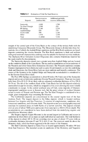
TABLE 4.1 Estimation of Utah Tar Sand Reserves
Known reserves Additional probable
Deposit (million bbl) reserves (billion bbl)
Sunnyside 4,400 1,700
Tar Sand Triangle 2,500 420
PR Spring 2,140 2,230
Asphalt Ridge 820 310
Circle Cliffs 590 1,140
Other 1,410 1,530
Total 11,8060 7,330
margin of the central part of the Uinta Basin at the contact of the tertiary beds with the
underlying Cretaceous Mesaverde Group. The Mesaverde Group is divided into three for-
mations, two of which, the Asphalt Ridge sandstone and the Rim Rock sandstone are beach
deposits containing the viscous bitumen. The Rim Rock sandstone is thick and uniform
with good reservoir characteristics and may even be suitable for thermal-recovery methods.
The Duchesne River formation (Lower Oligocene) also contains bituminous material but
the sands tend to be discontinuous.
The Sunnyside deposits extend over a greater area than Asphalt Ridge and are located
on the southwest flank of the Uinta Basin. The tar sand accumulations occur in sandstone of
the Wasatch and lower Green River formations (Eocene). The Wasatch sandstone contains
bitumen impregnation but is lenticular and occupies broad channels cut into the underlying
shale and limestone; the Green River beds are more uniform and laterally continuous. The
source of the bitumen in the Asphalt Ridge and Sunnyside accumulation is considered to
be the Eocene Green River shale.
The Peor (PR) Springs accumulation is about 60 miles (96.5 km) east of the Sunnyside
deposit and occurs as lenticular sandstone (Eocene Wasatch formation). There are two main
beds from 30 to 85 ft (9–26 m) thick with an estimated overburden thickness of 0 to 250 ft
(0–76 m). The tilt of the southern flank of the Uinta Basin has left this deposit relatively
undisturbed except for erosion, which has stripped it of its cover allowing the more volatile
constituents to escape. In the central southeast area of Utah, some deposits of bitumen-
impregnated sandstone occur in Jurassic rock, but the great volume of in-place bitumen
occurs in rocks of Triassic and Permian age. The Tar Sand Triangle is considered to be a
single, giant stratigraphic trap containing the bitumen.
The Californian deposits are concentrated in the coastal region west of the San
Andreas Fault. The largest deposit is the Edna deposit, which is located midway
between Los Angeles and San Francisco. It consists of conglomerate, sandstone, dia-
tomaceous sandstone, and siliceous shale. The deposit occurs as a stratigraphic trap and
outcrops in scattered areas on both flanks of a narrow syncline. The deposit extends
over an area of about 7000 acres and occurs from outcrop to a 100-ft (30-m) depth. The
accumulations are considered to have been derived from the underlying organic and
petroliferous Monterey shale.
The Sisquoc deposit (Upper Pliocene) is the second largest in California and occurs in
sandstone in which there are as many as eight individual tar sand units. The total thickness
of the deposit is about 185 ft (56 m) occurring over an area of about 175 acres with an
overburden thickness between 15 and 70 ft (4.6–21 m). The reservoir sands lie above the
Monterey shale, which has been suggested to be the source of the bitumen.
The third California deposit at Santa Cruz is located approximately 56 miles (90 km)
from San Francisco. The material occurs in sandstone of the Monterey and Vaqueros