
Page 93 - The Petroleum System From Source to Trap
P. 93
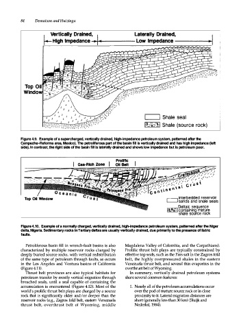
84     Demaison and Huizinga


                         V e rtically Drained,                   Laterally  Drained,
                      I
                                               I
                                                ..
                      � High Impedance -� ...  � -iooll  �  -  -  -  -  Low  Impedance -------1�


                                                                      L....-----'1  Shale seal
                                                                      f.s_-=s=- �1  Shale (source rock)


           Figure 4.9.  Example of a supercharged, vertically drained, high-impedance petroleum system, patterned after the
           Campeche-Reforma area, Mexico). The petroliferous part of the basin fill is vertically drained and  has high impedance (left
           side). ln contrast, the right side of the basin fill is laterally drained and shows low impedance but is petroleum poor.


                           O c e  a  n  i c
             T o p Oil  Window


           Figure 4.10.  Example of a normally charged, vertically drained, high-impedance petroleum system, patterned after the Niger
           delta, Nigeria. Sedimentary rocks in Tertiary deltas are usually vertically drained, due primarily to the presence of listric
           faults.

             Petroliferous  basin fill  in  wrench-fault  basins  is  also   Magdalena Valley of Colombia,  and  the  Carpathians).
           characterized  by  multiple  reservoir  rocks  charged  by   Prolific  thrust  belt  plays  are  typically  constrained  by
           deeply buried source rocks,  with  vertical  redistribution   effective top seals, such as the Fars salt in the Zagros fold
           of  the  same  type  of  petroleum  through  faults,  as  occurs   belt,  the  highly  overpressured  shales  in  the  eastern
           in  the  Los  Angeles  and  Ventura  basins  of  California   Venezuela  thrust belt, and several thin evaporites in the
           (Figure 4.11).                                    overthrt belt of Wyoming.
             Thrust  belt  provinces are also  typical  habitats  for   In  summary,  vertically  drained  petroleum  systems
           petroleum transfer by mostly  vertical  migration through   share several common features:
           breached  seals,  until  a  seal  capable of  containing  the
           accumulation  is  encountered  (Figure  4.12).  Most of the   1.  Nearly all of the petroleum accumulations occur
           world's prolific thrust belt plays are charged by a source   over the pod of mature source rock or in close
           rock  that  is significantly  older  and/or deeper  than  the   proximity to it. Lateral migration distances are
           reservoir  rocks  (e.g., Zagros  fold  belt,  eastern  Venezuela   short (generally less than 30 km) (Sluijk and
           thrust  belt,  overthrust  belt  of  Wyoming,  middle   Nederlof, 1984).