
Page 88 - The Petroleum System From Source to Trap
P. 88
4. Genetic Classification of Petroleum Systems 79
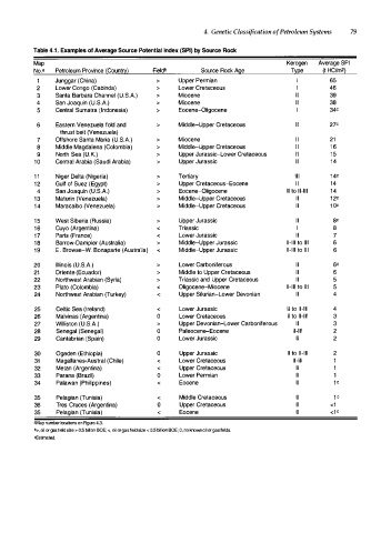
Table 4.1. Examples of Average Source Potential Index (SPI) by Source Rock
Map Kerogen Average SPI
No. a Petroleum Province (Count�) Fieldb Source Rock Age T�pe (t HC/m2)
Junggar (China) > Upper Permian I 65
2 Lower Congo (Cabinda) > Lower Cretaceous I 46
3 Santa Barbara Channel (U.S.A.) > Miocene II 39
4 San Joaquin (U.S.A.) > Miocene II 38
5 Central Sumatra (Indonesia) > Eocene-Oligocene I 34C
6 Eastern Venezuela fold and > Middle-Upper Cretaceous II 27C
thrust belt (Venezuela)
7 Offshore Santa Maria (U.S.A.) > Miocene I I 21
8 Middle Magdalena (Colombia) > Middi�Upper Cretaceous I I 1 6
9 North Sea (U.K.) > Upper Jurassic-Lower Cretaceous II 1 5
1 0 Central Arabia (Saudi Arabia) > Upper Jurassic II 1 4
1 1 Niger Delta (Nigeria) > Tertiary Ill 1 4 C
1 2 Gulf of Suez (Egypt) > Upper Cretaceous-Eocene II 14
4 San Joaquin (U.S.A.) > Eocene-Oligocene II to 11-111 1 4
1 3 Maturin (Venezuela) > Middle-Upper Cretaceous II 1 2 C
1 4 Maracaibo (Venezuela) > Middle-Upper Cretaceous II 1 0 C
1 5 West Siberia (Russia) > Upper Jurassic II ac
1 6 Cuyo (Argentina) < Triassic I 8
1 7 Paris (France) < Lower Jurassic II 7
1 8 Barrow-Dampier (Australia) > Middle-Upper Jurassic 11-111 to Ill 6
1 9 E . Browse-W. Bonaparte (Australia) < Middle-Upper Jurassic 11-111 to Ill 6
20 Illinois (U.S.A.) > Lower Carboniferous II 6C
21 Oriente (Ecuador) > Middle to Upper Cretaceous II 6
22 Northwest Arabian (Syria) > Triassic and Upper Cretaceous II 5
23 Plato (Colombia) < Oligocene-Miocene 11-111 to Ill 5
24 Northwest Arabian (Turkey) < Upper Silurian-Lower Devonian II 4
25 Celtic Sea (Ireland) < Lower Jurassic II to 11-111 4
26 Malvinas (Argentina) 0 Lower Cretaceous II to II-III 3
27 Williston (U.S.A.) > Upper Devonian-Lower Carboniferous II 3
28 Senegal (Senegal) 0 Paleocen�Eocene II-III 2
29 Cantabrian (Spain) 0 Lower Jurassic II 2
30 Ogaden (Ethiopia) 0 Upper Jurassic II to 11-111 2
31 Magallanes-Austral (Chile) < Lower Cretaceous 11-111 1
32 Metan (Argentina) < Upper Cretaceous II 1
33 Parana (Brazil) 0 Lower Permian II 1
34 Palawan (Philippines) < Eocene II 1 C
35 Pelagian (Tunisia) < Middle Cretaceous II 1 C
36 Tres Cruces (Argentina) 0 Upper Cretaceous II <1
35 Pelagian (Tunisia) < Eocene II <1 C
•Map number locations on Rgure 4.3.
b>, oil or gas field size > 0.5 billion BOE; <, oil or gas field size < 0.5 billion BOE; 0, no knov.n oil or gas fields.
cEstimated.