
Page 417 - Trenchless Technology Piping Installation and Inspection
P. 417
Planning and Safety Considerations for Trenchless Installation Methods 367
by vacuum excavation equipment. More information on locating
existing utilities can be found from the references at the end of this
book.
Subsurface Utility Engineering
This discussion of subsurface utility engineering (SUE) is based on the
ASCE standard, Standard Guidelines for the Collection and Depiction of
Existing Subsurface Utility Data, CI/ASCE 38-02, 2003. SUE can be
defined as “a branch of engineering that involves managing certain
risks associated with utility mapping at appropriate quality levels,
utility coordination, utility relocation design and coordination, utility
condition assessment, communication of utility data to concerned
parties, utility relocation cost estimates, implementation of utility
accommodation policies, and utility design.” The use of SUE offers an
opportunity for a more comprehensive and organized approach to the
location of existing underground utilities. This method provides more
in-depth information regarding existing utilities.
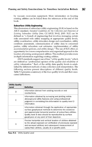
ASCE standards suggest use of four “utility quality levels,” which
are defined as “professional opinion of the quality and reliability of
utility information.” Each of the utility data quality levels is estab-
lished by different methods of data collection and interpretation. The
following sections present descriptions of different quality levels.
Table 9.1 presents a summary of the four quality levels and their asso-
ciated definitions.
Utility Quality
Level Definition
Information derived from existing records or oral
D
recollections.
Information obtained by surveying and plotting visible
above-ground utility features and using professional
C
judgment in correlating this information to quality level D
information.
Information obtained through the application of appropriate
surface geophysical methods to determine the existence
B and approximate horizontal position of subsurface utilities.
Quality level B data should be reproducible by surface
geophysics at any point of their depiction.
Precise horizontal and vertical location of utilities obtained
by the actual exposure (or verification of previously exposed
A
and surveyed utilities) and subsequent measurement of
subsurface utilities, usually at a specific point.
TABLE 9.1 Utility Quality Level