
Page 119 - Volcano and Geothermal Tourism
P. 119
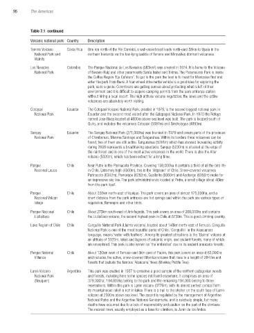
96     The Americas


               Table 7.1  continued

               Volcanic national park Country  Description
               Tenorio Volcano    Costa Rica  One km north of the Río Corobicí, a well-paved road leads north-east 58km to Upala in the
                 National Park and     northern lowlands via the low-lying saddle of Tenorio and Miravalles dormant volcanoes.
                 Vicinity
               Los Nevados     Colombia  The Parque Nacional de Los Nevados (583km ) was created in 1974. It is home to the Volcano
                                                                   2
                 National Park         of Nevado Ruiz and other paramounts Santa Isabel and Tolima. The Paramounts Park is inside
                                       the Coffee Region ‘Eje Cafetero’. To get to the park the best is to head for Manizales first and
                                       enter the park from there. A four-wheel-drive rental vehicle is a good idea for exploring the
                                       park, as is a guide: Colombians are getting serious about protecting what is left of their
                                       environment and it is difficult to acquire camping permits from the park entrance station
                                       without hiring a local escort. The high altitude volcano vegetation, the lakes and the active
                                       volcanoes are absolutely worth visiting.

               Cotopaxi        Ecuador  The Cotopaxi Volcano National Park, created in 1979, is the second biggest national park in
                 National Park         Ecuador and the second most visited after the Galapagos National Park. In 1970 the Refuge
                                       named Jose Rivas located at 4800m above sea level was built. The park is located south of
                                       Quito, and includes the volcanoes Cotopaxi (5897m) and Sincholagua (4893m).

               Sangay          Ecuador  The Sangay National Park (271,000ha) was founded in 1979 and covers parts of the provinces
                 National Park         of Chimborazo, Morona Santiago and Tungurahua. Within its borders three volcanoes can be
                                       found, two of them are still active. Tungurahua (5016m) which has showed increasing activity
                                       during 2008 represents a breathtaking spectacle. Sangay (5230m) is situated at the edge of
                                       the rainforest and is one of the most active volcanoes in the world. There is also the Altar
                                       volcano (5320m), which has been extinct for a long time.
               Parque          Chile   Near Putre in the Parinacota Province. Covering 138,000ha it contains a third of all the bird life
                 Nacional Lauca        in Chile. Extremely high (4500m), this is the ‘Altiplano’ of Chile. Snow-covered volcanoes
                                       Parinacota (6342m), Pomerape (6282m), Guallarite (6060m) and Acotango (6050m) make for
                                       an impressive sky line. The park administration is located at Putre, a small village about 46km
                                       from the park itself.
               Parque          Chile   About 228km north-east of Iquique. The park covers an area of almost 175,000ha, and a
                 Nacional Volcan       short distance from the park entrance are hot springs and within the park are various types of
                 Isluga                vegetation, flamingos and other birds.
               Parque Nacional    Chile  About 275km south-east of Antofagasta. This park covers an area of 268,000ha and contains
                 Llullaillaco          the Llullaillaco volcano, the second highest peak in Chile at 6739m. This is good climbing country.
               Lake Region of Chile   Chile  Conguillo National Park (Llaima volcano), located about 148km north-east of Temuco. Conguillo
                                       National Park is one of the most beautiful parks of Chile. ‘Conguillio’ in the Araucanian
                                       language, means ‘water with feathers’. Among its greatest attractions is the ‘Llaima’ volcano at
                                       an altitude of 3125m, lakes and lagoons of volcanic origin, and ancient forests, many of which
                                       are unexplored. This park is also known as ‘the umbrellas’ due to its ancient araucaria forests.
               Parque National    Chile  About 120km west of Temuco and 5km east of Pucón, this park covers an area of 63,000ha
                 Villarica             and includes the active, snow-covered Villarrica volcano that rises to a height of 2847m and
                                       forests that include the famous ‘Araucaria’ trees (Monkey Puzzle Tree).

               Lanin Volcano    Argentina  This park was created in 1937 to preserve a good sample of the northern patagonian woods
                 National Park         and forests, including here some species not found elsewhere. It comprises an area of
                 (Neuquen)             379,000ha; 194,600ha belong to the park and the remaining 184,000 belong to three
                                       reservations. Within this park is Lanin volcano (3776m), with its almost perfect conical form.
                                       Its mountaineous relief is rich in lakes. There is a trail to the shelter on the south face of Lanin
                                       volcano at 2300m above sea level. The ascent is regulated by the management of Argentine
                                       National Parks and the Argentine National Gendarmerie, and is relatively simple, but many
                                       deaths have occurred due to a lack of responsibility and caution on the part of the climbers.
                                       The nearest town, usually employed as a base for climbers, is Junín de los Andes.


       Ch07.indd   96                                                                              3/28/2010   1:27:54 PM