
Page 123 - Volcano and Geothermal Tourism
P. 123
100 The Americas
tourist in 1987 and in 2000 a pyroclastic flow Fault, part of the boundary between the Caribbean
killed a tourist and guide who were hiking in a and North American tectonic plates. In this region
dangerous area on an active flank of the volcano. the Middle America Trench, a major subduction
Although these events are rare, as long as Arenal zone, lies off the Pacific coast and the Cocos Plate
remains active they will continue to happen. is sinking beneath the Caribbean Plate, producing
Eruptions that lead to pyroclastic flows and hot volcanic activity inland of the coast. Guatemala
avalanches normally come without a geophysical has 37 volcanoes, 4 of which are currently active:
warning. They travel at speeds of 80–90km/hour, Pacaya, Santiaguito, Fuego and Tacaná. The
which do not allow time to escape if caught in its Guatemalan government has also protected more
path. As a result of this tragedy at Arenal local than 15 per cent of its land in national parks and
volcanologists have provided information to the other reserves. Tourism officially became
travel industry to establish safety guidelines for Guatemala’s second most important source of
travellers because it was important to restrict foreign exchange earnings, behind coffee, in
access to the slopes and streams that drain the 1993.
summit.
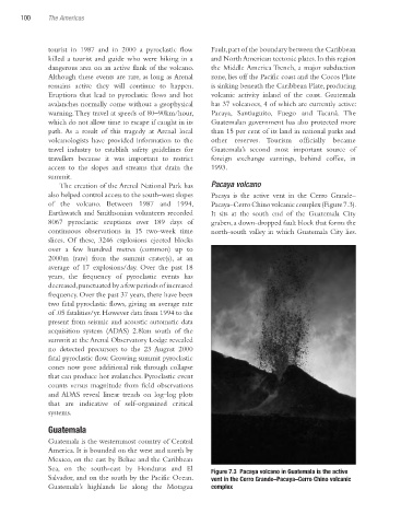
The creation of the Arenal National Park has Pacaya volcano
also helped control access to the south-west slopes Pacaya is the active vent in the Cerro Grande–
of the volcano. Between 1987 and 1994, Pacaya–Cerro Chino volcanic complex (Figure 7.3).
Earthwatch and Smithsonian volunteers recorded It sits at the south end of the Guatemala City
8067 pyroclastic eruptions over 189 days of graben, a down-dropped fault block that forms the
continuous observations in 15 two-week time north–south valley in which Guatemala City lies.
slices. Of these, 3246 explosions ejected blocks
over a few hundred metres (common) up to
2000m (rare) from the summit crater(s), at an
average of 17 explosions/day. Over the past 18
years, the frequency of pyroclastic events has
decreased, punctuated by a few periods of increased
frequency. Over the past 37 years, there have been
two fatal pyroclastic flows, giving an average rate
of .05 fatalities/yr. However data from 1994 to the
present from seismic and acoustic automatic data
acquisition system (ADAS) 2.8km south of the
summit at the Arenal Observatory Lodge revealed
no detected precursors to the 23 August 2000
fatal pyroclastic flow. Growing summit pyroclastic
cones now pose additional risk through collapse
that can produce hot avalanches. Pyroclastic event
counts versus magnitude from field observations
and ADAS reveal linear trends on log–log plots
that are indicative of self-organized critical
systems.
Guatemala
Guatemala is the westernmost country of Central
America. It is bounded on the west and north by
Mexico, on the east by Belize and the Caribbean
Sea, on the south-east by Honduras and El Figure 7.3 Pacaya volcano in Guatemala is the active
Salvador, and on the south by the Pacific Ocean. vent in the Cerro Grande–Pacaya–Cerro Chino volcanic
Guatemala’s highlands lie along the Motagua complex
Ch07.indd 100 3/28/2010 1:27:56 PM