
Page 215 - Volcano and Geothermal Tourism
P. 215
192 Asia
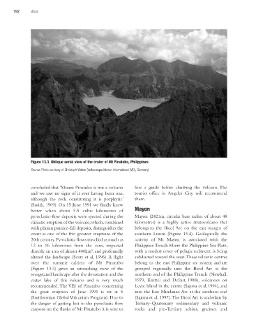
Figure 13.3 Oblique aerial view of the crater of Mt Pinatubo, Philippines
Source: Photo courtesy of Christoph Weber (Vulkanexpeditionen International (VEI), Germany)
concluded that ‘Mount Pinatubo is not a volcano hire a guide before climbing the volcano. The
and we saw no signs of it ever having been one, tourist office in Angeles City will recommend
although the rock constituting it is porphyric’ them.
(Smith, 1909). On 15 June 1991 we finally knew
better when about 5.5 cubic kilometres of Mayon
pyroclastic-flow deposits were ejected during the Mayon (2421m, circular base radius of about 48
climatic eruption of the volcano, which, combined kilometres) is a highly active stratovolcano that
with plinian pumice-fall deposits, distinguishes the belongs to the Bicol Arc on the east margin of
event as one of the five greatest eruptions of the southern Luzon (Figure 13.4). Geologically the
20th century. Pyroclastic flows travelled as much as activity of Mt Mayon is associated with the
12 to 16 kilometres from the vent, impacted Philippine Trench where the Philippine Sea Plate,
directly an area of almost 400km², and profoundly with a modest cover of pelagic sediment, is being
altered the landscape (Scott et al, 1996). A flight subducted toward the west. These volcanic centres
over the summit caldera of Mt Pinatubo belong to the east Philippine arc system and are
(Figure 13.3) gives an astonishing view of the grouped regionally into the Bicol Arc at the
revegetated landscape after the devastation and the northern end of the Philippine Trench (Newhall,
crater lake of this volcano and is very much 1979, Knittel and Defant, 1988), volcanoes on
recommended. The VEI of Pinatubo concerning Leyte Island in the centre (Sajona et al,1994), and
the great eruption of June 1991 is set at 6 into the East Mindanao Arc at the southern end
(Smithsonian Global Volcanism Program). Due to (Sajona et al, 1997). The Bicol Arc is underlain by
the danger of getting lost in the pyroclastic flow Tertiary–Quaternary sedimentary and volcanic
canyons on the flanks of Mt Pinatubo it is wise to rocks and pre-Tertiary schists, gneisses and
Ch13.indd 192 4/7/2010 12:03:41 PM