
Page 204 - Well Logging and Formation Evaluation
P. 204
194 Well Logging and Formation Evaluation
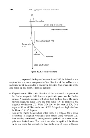
Derrick foor
Ground level or sea level
Depth reference level
True vertical depth TVD
Survey point
at md
Inclination
Borehole
Local gravity vector
Figure 13.1.1 Basic Definitions
Azimuth, expressed in degrees between 0 and 360, is defined as the
angle of the horizontal component of the direction of the wellbore at a
particular point measured in a clockwise direction from magnetic north,
grid north, or true north. These are defined:
• Magnetic north. This is the direction of the horizontal component of
the Earth’s magnetic field lines at a particular point on the Earth’s
surface. A magnetic compass will align itself to these lines. The angle
between magnetic north (MN) and true north (TN) is defined as the
magnetic declination (D). When MN lies to the west of TN, D is
negative. When MN lies to the east of TN, D is positive. Typical values
for D are -5 to +5 degrees.
• Grid north. Due to the curvature of the Earth, it is not possible to cover
the surface in a regular rectangular grid pattern using meridians (i.e.,
lines heading north/south), although such a grid will be almost rectan-
gular over limited areas. The central meridian in a grid will be identi-
cal to true north, but vertical grid lines to the west of center will point