
Page 185 - Whole Earth Geophysics An Introductory Textbook For Geologists And Geophysicists
P. 185
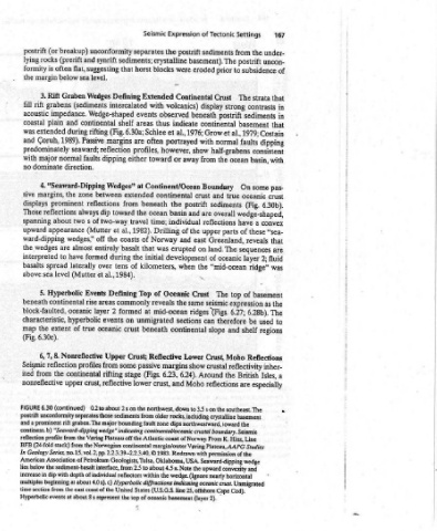
167     of    that   in   in   that   with     that   are   was   the   The   to   a
              under-   uncon-   contrasts   Costain   dipping   consistent   some pas-   crust   (Fig. 6.30b).   convex   “sea-   fluid   2;   basement   as   used   regions   Reflections   inher-   Isles,   especially

          Settings   the   from   postrift   subsidence   to   strata  The   Strong   sediments   basement   1979:   al.,   faults   ocean  basin,   On   oceanic   wedge-shaped,   have   a   these   of   reveals   sequences   layer   ridge”   of   top   expression   6.28b).   6.27;   be   shelf   and   Moho   reflectivity   British   are   the  southeast. The   basement   boundary.  Seismic   K.  Hinz,  Line   Studies  AAPG   Cod).

          of  Tectonic   sediments   basement). The   eroded   prior   Crust   display   postrift  beneath   continental   et  Grow   normal   with   half-grabens   the   from   Boundary   crust   true   and   sediments   overall   are   reflections   upper   parts   Greenland,   The   land.   on   oceanic   of   “mid-ocean   the   The   seismic   ridges  (Figs.   therefore   can   slope   Crust,   crustal   the  Around   reflections   crustal   with  permission  of  the  4.5  s.  No


          Expression   postrift   the   were   Continental   volcanics)   observed   indicate   al.,  1976;   et   portrayed   however,   show   away   or   Continent/Ocean   continental   postrift   the   and   basin   individual   the   of   east   and   erupted   development   when   Crust  Oceanic   same   the   mid-ocean   sections   continental   Lower   margins  show   6.24).   6.23,   Moho   and   the  northwest,  down  to  3.5  s  on      ic   Ve   margin/outer  Voring  Plat


         Seismic   separates  sediments;  crystalline   blocks   horst   Extended   with   events   thus   areas   6.30a;  Schlee   often   are   profiles,   toward  either   at   extended   beneath   ocean   the   travel   time;   Drilling  1982).   Norway   of   was   that   initial   the   kilometers,   of   of   Top   reveals  commonly   at   unmigrated   beneath   Reflective  Crust;   passive   stage   (Figs.   crust,  lower  and  a  prominent  rift  graben. The  major  bounding


              unconformity   synrift   flat,  suggesting   that   level.   Wedges  Defining   intercalated   Wedge-shaped   shelf  continental   (Fig.   Passive  margins   reflection   dipping   between   reflections   from   toward   dip   two-way   of   al.,   et  (Mutter   the   off   coasts   entirely   basalt   during  formed   tens   over   1984).   al.,   et   Defining  Events   areas   formed   2   layer   on  events   crust  oceanic   Upper   some   from   rifting   crust,


              breakup)   and  (prerift   below  sea   Graben   (sediments   impedance.   and   during  rifting   1989).   seaward;   normal   faults   direction.   “Seaward-Dipping  Wedges”   zone   the   prominent   always   s   two   appearance   wedges,”   almost   are   have   laterally   (Mutter   Hyperbolic   rise  continental   oceanic   hyperbolic   true   of   Nonreflective   profiles   continental   upper   (continued)   “Seaward-dipping  wedge”   from   American  Associati


             (or   rocks   often   is   margin   Rift   grabens   plain   extended   Coruh,   predominately   major   dominate   margins,   reflections   about   wedges   to   spread   sea   level   block-faulted,   characteristic,   extent   6.30c).   8.   7,   reflection   from   the   6.30   (24-fold  stack)   Geology  Series,   Hyperbolic  events  at
             postrift   lying   formity   the   3.   rift   fill   acoustic   coastal   was   and   with   no   4.   sive   displays   Those   spanning   upward   ward-dipping   the   interpreted   basalts   above   5.   beneath   the   map   (Fig.   6,   Seismic   ited   nonreflective   FIGURE   continent.  b)   reflection  profile   BFB   In   increase  in  dip  with   time  section  from


             Southeast                          Fasi   ete  a               F———            —                       sediments  lie  from


                                                      D
                                                      ees                                                     Each  profile  shows   of  the  continental  shelf  off  the  east
                                                      a  SLA  -   sediment- basalt   interface                 sedimentary  section.  Deeper  reflection  patterns  wedge  indicating  continental  crust  extended


                                                      =
           Crust   km   10                     Boundary   km   10      See             ro      =   as   <r           Cod,  part   Cape  water  layer  is  above  0.2  s.  Postrift


           Continental                                   =   =   =                            Crust           Seismic  reflection  profiles from  passive  continental  margins.   the  postrift  reflections  from  basement.  a)  Rift  graben   Offshore  25  from   transparent


           Extended   Northwest                Continent/Ocean   Wasi   =   E           Oceanic   Northwest   6.30   horizontal  the  type  of  crystalline   line  during  rifting.  U.S.G.S.   United  States.  The


                                                                                         ©
                                                                                              N
                                                                                                   ©
                      N
                              a
           a)   0   (Ss)  Uy  JOABLL  ABAA-OML   b)   "   (5)  euly  JOABLL  ABAA-OML   c)   {(s)  ew,  JOABsLL  ABAA-OML   gQ   FIGURE   prominent   suggest   coast  of  the