Page 341 - Whole Earth Geophysics An Introductory Textbook For Geologists And Geophysicists
P. 341

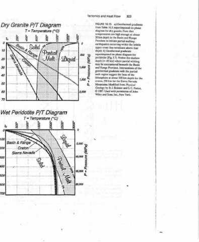
Geothermal  gradients   phase   on   that   about   at   Range   melting:   brittle   the   that   for   the  shallow   mehing   the   Basin   partial   of  the   for  the  depth   Nevada   Physical


          323      enough   and   beneath  Province.  Intersections  of  the   the   base   B.  3.  Skinner  and  S.C.  Porter,   permission  of  John

          Flow   a)   10.3,  superimposed  for  dry  granite.  Note   high   Basin   the   initiate  partial   thus  terminate  above  Geothermal  gradients   on  phase  diagram   (Fig.  2.7).  Notice   where  partial   gradients  with   the   150  km  about   for  the  Sierra   from   Sons,  Inc..  New  York.
          Heat   10.15   in   to  earthquakes  occurring  within   45  km)   encountered   region  suggest   at   Mountains.  Modified   with

          and   FIGURE   from  Table   diagram   temperatures  are   20  km   depth   Province   upper  crust   depth.  b)   superimposed   peridotite   depth   (=   may  be   Range   geothermal   lithosphere   craton,  250  km   Geology  by   1987.  Used   Wiley  and
          Tectonics                 and   melt   ©

                            (@dW)  e@inssetd  =
                                                                          (8d W)  einsselg   d
                        0   ei           §     ‘
                                                                   0     g     §       §     8
                                                                                       2
              3                                                                2             g


             Diagram   (°C)   fe   °                       Diagram   .  Temperature (°C)


             P/T   Temperature  T=   °                     P/T

             Granite   °                                   Peridotite   Ne


             Dry              8    8   &   8   @   R       Wet             8  8  ,  88

             a)                z=  Depth  (km)             b)               z=  Depth  (km)


                                                                                                        Flow  Map,   in   values   Rift)  and  at   region  of   and   the


                                                                                                XS   ~#   Heat   107?  W/m’).  High   W/m*). The   (near  the  coast)   Nevada
                                                                        --                       Muah

                                                                          ?   ‘              ---A.---->)   Regions  of  high  and  low  values.  expressed   Province:  Rio  Grande   0.09   of  the  Sierra
                                                                        i.                  rks     of Mexico   U.  S.  Department  of  Energy   x   4.2   =   —   forearc  region  years  ago.  Low  values  are  also  observed  in
                                                                 American   sp   2   a   Pt   Nef  oa  bagel   fe  je   Continental)   4   py   ‘   jan   ;   \   Coast  ne   eS   oe   Gulf   from   1991).   HFU  flow  units  (1   Range   and   values  (0.05  by  normal   the   in  0.05  W/m")  low  marks  the  region   Mountains).
                                                                    y
                                                                      i


                                                                 North  MARS  osaiatee. a   t   S   oe   Marathon’.   Gu   a?   \.<   (simplified   al.,   et  Blackwell   heat   rifting  (Basin   is  dominated   low  (<   about  20  million   (Appalachian


                                               2)     0.09           wate                        a aa   United  States   Mountains).  A  prominent   East
                                               (W/m   0.09   -   ‘<0.05   rencmcag   i  t  f   *          Steele.  1989,  and  highlighted.  Older  maps  may  show  values  in  observed  in  areas  of  continental   continental  craton  Pacific  Northwest  shows  a   the  zone  in
                                                                        i


                                               Flow   >   0.05   Pi   i   i   4,   3                    Heat flow  map  of the   and   hotspot. The   the   (Cascade  plate  convergence  ceased   collision

                                               Heat   [es]   [_]   Eeq   an   i:  <<  i   be)           10.14   Blackwell   0.09  W/m’)  are   in   volcanic  arc   the   Paleozoic  continental

                                                                   Who,
                                                                                                        FIGURE   1996:  sce  also   W/m‘.  are   the  Yellowstone   ongoing  subduction   at   high   Mountains.  where
                                                                    ukzaIQ  OB                               (>   a
   336   337   338   339   340   341   342   343   344   345   346