
Page 84 - Moving the Earth_ The Workbook of Excavation
P. 84
SURVEYS AND MEASUREMENTS
2.34 THE WORK
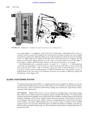
FIGURE 2.31 Depthmaster—attached to excavator. (Courtesy of Laser Alignment Inc.)
excavating dipper is in alignment, whereas the left or right light would indicate that a move to
extend or retract is needed. The depth of cut is indicated by the display of light in the strip of lights
up and down on the panel. When the dipper is not in the laser beacon’s beam because it is too high,
or low, no depth light will be lighted. If the light with a horizontal bar on it is lighted, then the
bucket in a horizontal digging position is at the correct excavating depth. If one of the upper or
lower lights is lighted, then the bucket will have to be lowered or raised to be on grade.
1
The Depthmaster gives a constant accuracy “on grade” to ⁄ 6 inch or ⁄ 2 inch depending
1
on the job site requirements. It has 9 inches of vertical receiving cells and can receive from any
laser in all directions, that is, 360° horizontally. The power used for this instrument is 11 to 30
volts direct current, and its operating range is 1,000 feet from the laser. The operator can have a
readout panel in the cab of his or her hydraulic excavator in case there is difficulty reading the
Depthmaster on the dipper stick.
GLOBAL POSITIONING SYSTEM
The global positioning system (GPS) is a satellite-based system developed for military use but suc-
cessfully transferred for many civilian uses. GPS makes use of 24 satellites. Commercial uses include
land surveying, vehicle navigation and tracking, mining and construction, agricultural systems,
and many other applications.
GPS Methods. Mobile GPS receivers can be mounted on earthmoving or agricultural equip-
ment. The receivers obtain positions by using the signals from the GPS satellites. Two-dimensional
positions (latitude and longitude) use the signals from three satellites, and three-dimensional positions
(latitude, longitude, and elevation) require signals from four satellites. GPS positions are based
on a technique called trilateration, which is similar to triangulation but is based on the distances
to the satellites, not angles. GPS hardware has very accurate clocks, so timing of these satellite
signals is known very accurately. The GPS receiver calculates the distance to satellites, using the sig-
nals from them and their location in the sky. Those distances are then used to calculate the receiver’s
location on earth.